The National Geologic Map Database is migrating to a new infrastructure. We apologize for any service disruptions during this process.
|
|---|


- Usage in publication:
-
- Bentley member
- Modifications:
-
- Original reference
- Dominant lithology:
-
- Sand
- Clay
- AAPG geologic province:
-
- Arkla basin
Summary:
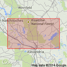
Pg. 78 (fig. 6), 157-160. Bentley member. The series of Pleistocene deposits in Grant and La Salle Parishes, central Louisiana, is divided into four members, their names corresponding to the four distinct depositional terrace surfaces: Williana (oldest), Bentley, Montgomery, and Prairie. Bentley member consists of sequence which grades from coarse basal materials to silty clays in upper part of section; differs from Williana sediments in that they are thinner, and show greater variation in central and upper part of sequence. Average thickness less than 60 feet. Unconformably overlies Miocene Catahoula formation; along eastern valley wall of Nantaches Lake is in unconformable contact with Jackson Eocene. Age is Pleistocene.
Well exposed along LA Highway 19 between Bentley and Colfax, Grant Parish, and between Trout and White Sulphur Springs, La Salle Parish, and on U.S. Highway 71 between Grant-Rapides Parish line and Bayou Rigolette, central LA.
Source: US geologic names lexicon (USGS Bull. 1200, p. 303-304).
- Usage in publication:
-
- Bentley formation
- Modifications:
-
- Revised
- AAPG geologic province:
-
- Arkla basin
Summary:
Pg. 177-180, pl. 1 [geol. map]. Bentley formation. Rank raised to formation. Described in Rapides and Avoyelles Parishes where along walls of Red River Valley it has an average thickness of 80 to 100 feet; locally overlies undifferentiated Fleming formation.
Source: US geologic names lexicon (USGS Bull. 1200, p. 303-304).
- Usage in publication:
-
- Bentley Formation
- Modifications:
-
- Not used (revised 1992 edition)
- AAPG geologic province:
-
- Gulf Coast basin
Summary:
[Bentley Formation not used (revised 1992 edition). = lower part of Lissie Formation. See entry under Lissie.]
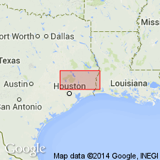
1968 edition: Bentley Formation. Clay, silt, sand, and minor amount of gravel. Gravel slightly coarser than in overlying Montgomery Formation [= upper part of Lissie, revised 1992 edition], noncalcareous, iron oxide concretions more abundant than in Montgomery. Fluviatile. Very gently rolling. Thickness about 100 feet. Previously mapped as lower part of Lissie Formation. Overlies Willis Formation (Pleistocene). Age is Pleistocene. Mapped mostly in central and northeast parts of map sheet in discontinuous, roughly southwest-northeast trending belt in northern Harris, southern Montgomery, northern Liberty, southern San Jacinto, northern Hardin, southern Polk, southern and eastern Tyler, north-central Jasper, and central Newton Cos., TX.
Source: Modified from GNU records (USGS DDS-6; Denver GNULEX).

- Usage in publication:
-
- Bentley Formation
- Modifications:
-
- Not used
- AAPG geologic province:
-
- Gulf Coast basin
Summary:
Is Pleistocene formation that is not used in this map sheet. The Lissie Formation (Pleistocene) is mapped in the eastern part of this map sheet and it is noted that the Montgomery and Bentley Formations (upper and lower units of the Lissie) are essentially indistinguishable and are thus not separately mapped. [See Lissie Formation.]
Source: GNU records (USGS DDS-6; Denver GNULEX).
For more information, please contact Nancy Stamm, Geologic Names Committee Secretary.
Asterisk (*) indicates published by U.S. Geological Survey authors.
"No current usage" (†) implies that a name has been abandoned or has fallen into disuse. Former usage and, if known, replacement name given in parentheses ( ).
Slash (/) indicates name conflicts with nomenclatural guidelines (CSN, 1933; ACSN, 1961, 1970; NACSN, 1983, 2005, 2021). May be explained within brackets ([ ]).