The National Geologic Map Database is migrating to a new infrastructure. We apologize for any service disruptions during this process.
|
|---|


- Usage in publication:
-
- "Belridge diatomite"
- Modifications:
-
- Named
- Dominant lithology:
-
- Diatomite
- AAPG geologic province:
-
- San Joaquin basin
Summary:
Term "Belridge diatomite" suggested by W.F. Barbat (pers. commun.) for diatomite facies of Reef Ridge shale, San Joaquin Valley, CA. However unit has not as yet been clearly differentiated from typical Reef Ridge lithology into which it grades laterally.
Source: GNU records (USGS DDS-6; Menlo GNULEX).
- Usage in publication:
-
- Belridge Diatomite Member*
- Modifications:
-
- Principal reference
- Revised
- Age modified
- Biostratigraphic dating
- Adopted
- AAPG geologic province:
-
- San Joaquin basin
Summary:
Belridge Diatomite of Siegfus (1939) is revised to uppermost of four members of Monterey Shale, and geographically restricted to area northeast of San Andreas fault. Is discontinuously exposed in foothills of Temblor Range from McKittrick to Maricopa. Composed of white-weathering soft fissile to punky diatomite. Just west of Taft is as much as 2,200 feet thick. Grades downward into McLure Shale Member of Monterey Shale. Unconformably underlies Tulare Formation west of Taft; in places disconformably underlies Etchegoin Formation. Intertongues with Santa Margarita Formation in southeastern Temblor Range. In exposed sections contains foraminifers and fish scales diagnostic of late Mohnian Stage, late Miocene (R.L. Pierce, oral commun., 1967). In Temblor Range, age of Belridge is late Miocene (late Mohnian). Belridge Diatomite Member of Monterey Shale adopted by the USGS.
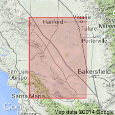
Type section: near mouth of Chico Martinez Creek, in SE/4 sec. 2 T. 29 S., R. 20 E. [Carneros Rocks 7.5-min quadrangle, Kern Co.,] eastern edge of San Joaquin Valley, CA. Named from South Belridge oil field.
Source: Modified from GNU records (USGS DDS-6; Menlo GNULEX); Changes in stratigraphic nomenclature, 1973 (USGS Bull. 1395-A, p. A4-A5).
For more information, please contact Nancy Stamm, Geologic Names Committee Secretary.
Asterisk (*) indicates published by U.S. Geological Survey authors.
"No current usage" (†) implies that a name has been abandoned or has fallen into disuse. Former usage and, if known, replacement name given in parentheses ( ).
Slash (/) indicates name conflicts with nomenclatural guidelines (CSN, 1933; ACSN, 1961, 1970; NACSN, 1983, 2005, 2021). May be explained within brackets ([ ]).