The National Geologic Map Database is migrating to a new infrastructure. We apologize for any service disruptions during this process.
|
|---|


- Usage in publication:
-
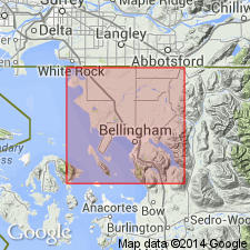
- Bellingham glaciomarine drift
- Modifications:
-
- Original reference
- Dominant lithology:
-
- Clay
- AAPG geologic province:
-
- Bellingham basin
Summary:
Pg. 1469 (table 1), 1475, pl. 3. Bellingham glaciomarine drift. (Also referred to as Bellingham drift.) Consists of blue-gray to brown unsorted and unstratified pebbly, sandy clay and pebble clay. Thickness 10 to 70 feet. Overlies Deming sand (new). Older than Sumas till; contact not observed. In many places resembles true till, but elsewhere grades into clay with only few pebbles. Marine fossils indicate marine origin. Radiocarbon ages of 12,090 +/-350 yr B.P. and 11,800 +/-400 yr B.P. were obtained from peat and wood. Age is late Pleistocene.
Named for occurrence in vicinity of Bellingham and Bellingham Bay, Puget Lowland, northwestern WA.
Source: US geologic names lexicon (USGS Bull. 1350, p. 57); supplemental information from GNU records (USGS DDS-6; Menlo GNULEX).
- Usage in publication:
-
- Bellingham Drift*
- Modifications:
-
- Adopted
- Mapped
- AAPG geologic province:
-
- Puget Sound province
Summary:
Named for exposures 8 mi northeast of Bellingham. Type locality designated in sec.34 T39N R4E, western Whatcom Co, WA, where unit caps section. Consists of blue-gray, unsorted, unstratified pebbly, sandy silt and pebbly clay. Derived from rock debris melted out of floating ice and deposited on sea floor. Overlies Deming Sand; underlies Quaternary sand and gravel. Locally contains mollusks and wood with radiocarbon ages between 12000 and 11000 yr B.P. Maximum thickness is 70 ft. Is part of Everson interstage of Fraser Glaciation. Is Pleistocene age.
Source: GNU records (USGS DDS-6; Menlo GNULEX).
For more information, please contact Nancy Stamm, Geologic Names Committee Secretary.
Asterisk (*) indicates published by U.S. Geological Survey authors.
"No current usage" (†) implies that a name has been abandoned or has fallen into disuse. Former usage and, if known, replacement name given in parentheses ( ).
Slash (/) indicates name conflicts with nomenclatural guidelines (CSN, 1933; ACSN, 1961, 1970; NACSN, 1983, 2005, 2021). May be explained within brackets ([ ]).