


- Usage in publication:
-
- Bellefonte dolomite*
- Modifications:
-
- Original reference
- Dominant lithology:
-
- Dolomite
- Limestone
- AAPG geologic province:
-
- Appalachian basin
Summary:
Pg. 552, 553, 652-660, pl. 27. Bellefonte dolomite. At Bellefonte, Centre County, central Pennsylvania, it is 2,145 feet thick. Upper 400 feet consists of mostly argillaceous, highly magnesian limestone, compact, often laminar, easily weathered, of light-gray color, and unfossiliferous. Lower 1,745 feet consist of yellowish-gray or drab, generally fine-grained and occassionally laminated dolomite, alternating with fewer ledges of comparatively dark, finely crystalline dolomite, both generally in rather even layers and of medium thickness, with cherty beds 800 to 900 feet below top. Is unconformably overlain by Upper Stones River limestone [Carlim limestone] and underlain by Axeman[n] limestone. Age is Early Ordovician (Canadian).
[GNC remark (ca. 1936, US geologic names lexicon, USGS Bull. 896, p. 152): The Bellefonte dolomite is top formation of Beekmantown group in central Pennsylvania (Centre and Blair Counties).]
Source: Publication; US geologic names lexicon (USGS Bull. 896, p. 152).
- Usage in publication:
-
- Bellefonte dolomite
- Modifications:
-
- Areal extent
- AAPG geologic province:
-
- Appalachian basin
Summary:
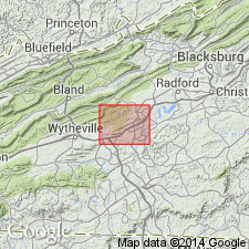
Geographically extended the Bellefonte dolomite to VA. Unit is less than 50 feet thick in the Draper Mountain area of VA where it conformably overlies the Draper dolomite member of the Nittany formation and unconformably underlies the Mosheim limestone of the Stones River group. Unit is of Early Ordovician (Canadian) age. Author uses Bellefonte in this area as opposed to Beekmantown which has been used by previous authors and in others areas of VA.
Source: GNU records (USGS DDS-6; Reston GNULEX).
- Usage in publication:
-
- Bellefonte dolomite*
- Modifications:
-
- Overview
- AAPG geologic province:
-
- Appalachian basin
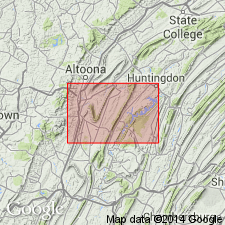
Summary:
The Bellefonte dolomite in Hollidaysburg and Huntingdon quadrangles of PA includes all of the dolomites above the Axemann limestone and below the Carlim limestone. The thickness of the Bellefonte in this area is about 1000 feet south of Roaring Spring and about 1250 feet east of Williamsburg. Unit is part of the Beekmantown group.
Source: GNU records (USGS DDS-6; Reston GNULEX).
- Usage in publication:
-
- Bellefonte formation
- Modifications:
-
- Revised
- AAPG geologic province:
-
- Appalachian basin
Summary:
The Bellefonte is revised to the Bellefonte formation in VA as shown on the geologic map of Virginia.
Source: GNU records (USGS DDS-6; Reston GNULEX).
- Usage in publication:
-
- Bellefonte Formation
- Modifications:
-
- Overview
- AAPG geologic province:
-
- Appalachian basin
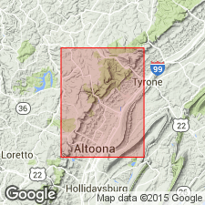
Summary:
Bellefonte Formation extends throughout central PA but thins to the west and north where it is truncated against the Axemann and Nittany Formations. To the south and east, it grades laterally into the Rockdale Run Formation. Unit is dominantly medium gray dolosiltite. Contains minor amounts of chert and sandstone. Gradationally underlies Loysburg Formation. Thickness of the Bellefonte is estimated at 300+/-50 m, but it may be much thicker. The best exposure is east of the mapped area in the Tyrone 7.5-min quad, along PA Rte 453, about 1 km southeast of Shoenberger and southeastward for 0.7 km. Age is Early and Middle Ordovician.
Source: GNU records (USGS DDS-6; Reston GNULEX).
For more information, please contact Nancy Stamm, Geologic Names Committee Secretary.
Asterisk (*) indicates published by U.S. Geological Survey authors.
"No current usage" (†) implies that a name has been abandoned or has fallen into disuse. Former usage and, if known, replacement name given in parentheses ( ).
Slash (/) indicates name conflicts with nomenclatural guidelines (CSN, 1933; ACSN, 1961, 1970; NACSN, 1983, 2005, 2021). May be explained within brackets ([ ]).