The National Geologic Map Database is migrating to a new infrastructure. We apologize for any service disruptions during this process.
|
|---|


- Usage in publication:
-
- Bell Brook Formation
- Modifications:
-
- Named
- Dominant lithology:
-
- Conglomerate
- Siltstone
- Slate
- AAPG geologic province:
-
- New England province
Summary:
Pg. 28-33, pl. 1. Bell Brook Formation. Consists of an older conglomerate member about 5,000 feet thick and a younger member about 6,000 feet thick that consists of olive-green siltstone and slate. May overlie Meduxnekeag Formation. Age is Silurian(?) and Devonian(?).
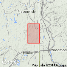
[Type locality]: Bell Brook in central part of T.C., R. 2, Bridgewater quadrangle, northern ME.
Source: US geologic names lexicon (USGS Bull. 1350, p. 56-57).
For more information, please contact Nancy Stamm, Geologic Names Committee Secretary.
Asterisk (*) indicates published by U.S. Geological Survey authors.
"No current usage" (†) implies that a name has been abandoned or has fallen into disuse. Former usage and, if known, replacement name given in parentheses ( ).
Slash (/) indicates name conflicts with nomenclatural guidelines (CSN, 1933; ACSN, 1961, 1970; NACSN, 1983, 2005, 2021). May be explained within brackets ([ ]).