

- Usage in publication:
-
- Beaverdam Amphibolite
- Modifications:
-
- Named
- Dominant lithology:
-
- Amphibolite
- AAPG geologic province:
-
- Piedmont-Blue Ridge province
Summary:
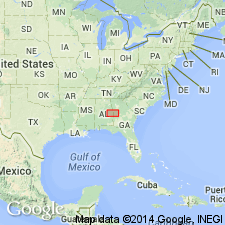
Named the Beaverdam Amphibolite for Beaverdam Creek, Randolph Co., AL. Unit contains dark-green to gray actinolite-tremolite amphibolite that occurs as layers in the Roopville Formation of the Heard Group. The Beaverdam is of middle Paleozoic age.
Source: GNU records (USGS DDS-6; Reston GNULEX).
For more information, please contact Nancy Stamm, Geologic Names Committee Secretary.
Asterisk (*) indicates published by U.S. Geological Survey authors.
"No current usage" (†) implies that a name has been abandoned or has fallen into disuse. Former usage and, if known, replacement name given in parentheses ( ).
Slash (/) indicates name conflicts with nomenclatural guidelines (CSN, 1933; ACSN, 1961, 1970; NACSN, 1983, 2005, 2021). May be explained within brackets ([ ]).