The National Geologic Map Database is migrating to a new infrastructure. We apologize for any service disruptions during this process.
|
|---|


- Usage in publication:
-
- Beaver Bay Group
- Modifications:
-
- Named
- Dominant lithology:
-
- Sandstone
- Breccia
- Siltstone
- AAPG geologic province:
-
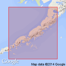
- Alaska Peninsula province
- Alaska Southwestern region
Summary:
Pt. 1, p. 88-89, 95-97; Pt. 2, maps. Beaver Bay Group. Name proposed for 20,000 to 25,000 feet of volcanic sandstones, conglomerates, breccias, and black siltstones exposed along west and north shores of Beaver Bay and in mountains bordering lower part of Beaver Valley. In Port Moller-Unga Island and Mount Veniaminof areas, includes Tolstoi (new) and Stepovak Formations; in Cold Bay area, includes Belkofski Formation. Unconformably overlies Hoodoo (new) and Chignik Formations. Underlies Bear Lake Formation (new). Age is Paleocene, Eocene, and Oligocene [Paleogene].
Type locality: Port Moller-Unga Island area, Alaska Peninsula, southwestern AK. Named from exposures along west and north shores of Beaver Bay and in mountains bordering lower part of Beaver River.
Source: US geologic names lexicon (USGS Bull. 1350, p. 52); supplemental information from GNU records (USGS DDS-6; Menlo GNULEX).
For more information, please contact Nancy Stamm, Geologic Names Committee Secretary.
Asterisk (*) indicates published by U.S. Geological Survey authors.
"No current usage" (†) implies that a name has been abandoned or has fallen into disuse. Former usage and, if known, replacement name given in parentheses ( ).
Slash (/) indicates name conflicts with nomenclatural guidelines (CSN, 1933; ACSN, 1961, 1970; NACSN, 1983, 2005, 2021). May be explained within brackets ([ ]).