The National Geologic Map Database is migrating to a new infrastructure. We apologize for any service disruptions during this process.
|
|---|


- Usage in publication:
-
- Beaumont clays*
- Modifications:
-
- Original reference
- Dominant lithology:
-
- Clay
- Sand
- AAPG geologic province:
-
- Gulf Coast basin
Summary:
William Kennedy, pls. 1, 2, p. 20, 27. Beaumont clays. Brown, blue, yellow, gray, and black clays, in places carrying nodules of limestone irregularly distributed through the clays; interstratified with gray, grayish white, brown and blue sands. Thickness 25 to 400 feet. Overlies Columbia sands (Lissie formation] and underlies Recent coastal marsh deposits in eastern division of Texas-Louisiana Gulf Coastal Plain. [Age is Pleistocene.]
[Named from Beaumont, Jefferson Co., eastern TX.]
Source: US geologic names lexicon (USGS Bull. 896, p. 136).
- Usage in publication:
-
- Beaumont clay*
- Modifications:
-
- Areal extent
- AAPG geologic province:
-
- Gulf Coast basin
Summary:
Beaumont clay. Gave thickness of 300 to 900 feet. [Age is Pleistocene.]
Source: US geologic names lexicon (USGS Bull. 896, p. 136).

- Usage in publication:
-
- Beaumont clay*
- Modifications:
-
- Areal extent
- AAPG geologic province:
-
- Gulf Coast basin
Summary:
Pg. 789. Beaumont clay is unconformably on Lissie formation. [Age is Pleistocene.]
Source: US geologic names lexicon (USGS Bull. 1200, p. 256).
- Usage in publication:
-
- Beaumont formation
- Modifications:
-
- Not used
- AAPG geologic province:
-
- Gulf Coast basin
Summary:
Lake Charles and Ingleside formations (both new) replace Beaumont formation.
Source: US geologic names lexicon (USGS Bull. 1200, p. 256).
- Usage in publication:
-
- Beaumont clay (Sixth Street)
- Modifications:
-
- Areal extent
- AAPG geologic province:
-
- Gulf Coast basin
Summary:
Pg. 1695 (fig. 1), 1708-1709. Quaternary deposits of Texas Coastal Plain between Brazos River and Rio Grande are divided into (ascending) Willis, Gay Hill, Bastrou Park, Uvalde, Asylum, Capitol, Beaumont (Sixth Street), Live Oak Bar (approximately of Beaumont age), First Street, Riverview, and Sand Beach terrace deposits. [Age is Pleistocene.]
Source: US geologic names lexicon (USGS Bull. 1200, p. 256).
- Usage in publication:
-
- Beaumont formation
- Modifications:
-
- Revised
- AAPG geologic province:
-
- Gulf Coast basin
Summary:
Pg. 1830-1831. In southwestern Louisiana, Beaumont formation is divided into Oberlin (lower Beaumont) and Eunice (upper Beaumont). [Age is Pleistocene.]
Source: US geologic names lexicon (USGS Bull. 1200, p. 256).
- Usage in publication:
-
- Beaumont Formation
- Modifications:
-
- Mapped 1:250k
- Dominant lithology:
-
- Clay
- Silt
- Sand
- AAPG geologic province:
-
- East Texas basin
- Gulf Coast basin
Summary:
Pamphlet [p. 1-2]. Beaumont Formation. Mostly clay, silt, and sand; includes mostly stream channel, point bar, natural levee, backswamp, and to a lesser extent coastal marsh and mud-flat deposits; concretions of calcium carbonate, iron oxide, and iron-manganese oxides in zone of weathering; surface almost featureless, characterized by relict river channels shown by meander patterns and pimple mounds on meanderbelt ridges, separated by areas of low, relatively smooth, featureless backswamp deposits without pimple mounds; thickness 100+/- feet. Is younger than Pleistocene age Lissie Formation [mapped as Montgomery and Bentley Formations in 1968 edition]. Older than Deweyville Formation (Holocene or late? Pleistocene). [Equivalent to Prairie Allogroup of Louisiana.] Age is considered Pleistocene. Subdivided into:
(1) map unit Qbs, dominantly sand and silt of moderate permeability, includes meanderbelt, levee, crevasse splay, and distributary sands;
(2) map unit Qbc, dominantly clay and mud of low permeability and high to very high shrink-swell potential, includes interdistributary muds, abandoned channel-fill muds, and fluvial overbank muds; and
(3) map unit Qbb, barrier island and beach deposits of high to very high permeability, probably part of "Ingleside" barrier island system, characterized by pimple mounds and rounded depressions, includes beach, foredunes, barrier-strandplain-chenier vegetated flats, thickness <30 feet.
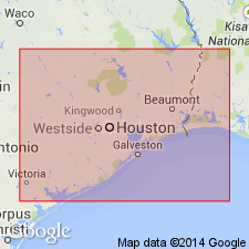
[Most notable exposures in Beaumont region, in Orange, Newton, Jasper, Hardin, Jefferson, Liberty, Harris, and Montgomery Cos., eastern TX.]
Source: Publication.

- Usage in publication:
-
- Beaumont Formation
- Modifications:
-
- Mapped 1:250k
- Dominant lithology:
-
- Clay
- Silt
- Sand
- AAPG geologic province:
-
- Gulf Coast basin
Summary:
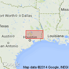
Beaumont Formation. Clay, silt, and sand; concretions of calcium carbonate, iron oxide, and iron-manganese oxides common in zone of weathering. Thickness about 100 feet. Two subunits are distinguished in map area: (1) dominantly clay and mud of low permeability; and (2) dominantly clayey sand and silt of low to moderate permeability. Overlies Lissie Formation; underlies Quaternary alluvium. Age is Pleistocene.
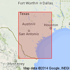
Mapped in Jackson, Wharton, Matagorda, Colorado, Fort Bend, and Austin Cos., southeastern TX.
Source: Modified from GNU records (USGS DDS-6; Denver GNULEX).
- Usage in publication:
-
- Beaumont Formation*
- Modifications:
-
- Areal extent
- AAPG geologic province:
-
- Gulf Coast basin
Summary:
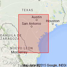
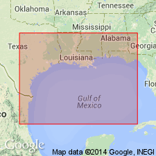
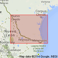
Includes two facies: 1) distributary channel (3-10 m thick in outcrop); thickens south to more than 100 m in subsurface), and 2) interdistributary mud (5-10 m thick in outcrop; more than 100 m in subsurface). Outcrop area shown on this map connects to south with Austin and Monterrey 4 deg x 6 deg quads. These maps show the exposed extent of Beaumont in this part of the TX and LA parts of Gulf Coast basin. Of late Pleistocene age.
Source: GNU records (USGS DDS-6; Denver GNULEX).
- Usage in publication:
-
- Beaumont Formation*
- Modifications:
-
- Areal extent
- AAPG geologic province:
-
- Gulf Coast basin
Summary:
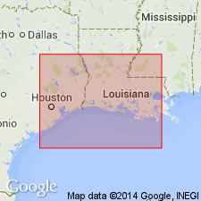
Beaumont Formation. Outcrop area shown on this map connects with the White Lake 4 x 6 degrees quadrangle to the north and the Monterrey 4 x 6 degrees quadrangle to the south; together, these maps show the extent of the formation. Includes three facies: (1) beach and nearshore marine sand, 3 to 15 m thick; (2) delta sand and silt, 3 to 10 m thick on outcrop (thickens to the south in subsurface to 100+ m thick); (3) delta silt and clay, 5 to 10 m thick at north edge of outcrop (thickens to the south in subsurface to 100+ m thick). Dips seaward beneath Holocene deposits. Rests disconformably on Lissie Formation. Age is late Pleistocene.
Source: Modified from GNU records (USGS DDS-6; Denver GNULEX).
- Usage in publication:
-
- Beaumont Formation*
- Modifications:
-
- Areal extent
- AAPG geologic province:
-
- Gulf Coast basin
Summary:
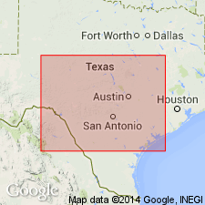
Beaumont Formation. Outcrop area shown on this map connects with the Austin and White Lake 4 x 6 degrees quadrangles to the north; together, these maps show the extent of the formation. Includes three facies: (1) relict beach ridge and associated sand, 5 to 15 m thick; (2) distributary channel, 3 to 10 m thick on outcrop, 100+ m thick in subsurface; (3) interdistributary, 5 to 10 m thick on outcrop, 100+ m thick in subsurface. Distributary and interdistributary facies intertongue. Dips seaward beneath Holocene deposits. Rests disconformably on Lissie Formation. Age is late Pleistocene.
Source: Modified from GNU records (USGS DDS-6; Denver GNULEX).
For more information, please contact Nancy Stamm, Geologic Names Committee Secretary.
Asterisk (*) indicates published by U.S. Geological Survey authors.
"No current usage" (†) implies that a name has been abandoned or has fallen into disuse. Former usage and, if known, replacement name given in parentheses ( ).
Slash (/) indicates name conflicts with nomenclatural guidelines (CSN, 1933; ACSN, 1961, 1970; NACSN, 1983, 2005, 2021). May be explained within brackets ([ ]).