

- Usage in publication:
-
- Beartrap Canyon Formation
- Modifications:
-
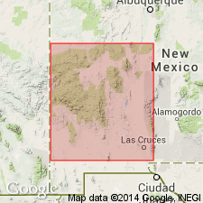
- Areal extent
- AAPG geologic province:
-
- Orogrande basin
Summary:
Should not be used outside northern San Mateo Range, Socorro Co, NM, Orogrande basin. Original definition included cauldron-fill units of two or more overlapping cauldrons in the northern San Mateo Mountains that range from about 30 m.y. to 14 m.y.
Source: GNU records (USGS DDS-6; Denver GNULEX).
For more information, please contact Nancy Stamm, Geologic Names Committee Secretary.
Asterisk (*) indicates published by U.S. Geological Survey authors.
"No current usage" (†) implies that a name has been abandoned or has fallen into disuse. Former usage and, if known, replacement name given in parentheses ( ).
Slash (/) indicates name conflicts with nomenclatural guidelines (CSN, 1933; ACSN, 1961, 1970; NACSN, 1983, 2005, 2021). May be explained within brackets ([ ]).