The National Geologic Map Database is migrating to a new infrastructure. We apologize for any service disruptions during this process.
|
|---|


- Usage in publication:
-
- Bear formation
- Modifications:
-
- Original reference
- Dominant lithology:
-
- Sandstone
- Shale
- AAPG geologic province:
-
- Central Montana uplift
Summary:
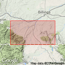
Pg. 15 (table), 17-20, pls. 1, 2. Bear formation. Name applied to unit, 500 to 600 feet thick, that occurs above Hell Creek formation and below the Fort Union (No. 1 or Lebo). Consists of alternating pale cross-bedded sandstones and shales. Contains turtle bones but no dinosaurs or mammals. All beds are tilted, but no evidence of angular unconformity. Change from Hell Creek to Bear is more abrupt than from Bear to Fort Union No. 1, the latter being transitional through a thickness of 15 to 20 feet, boundary here being taken arbitrarily at a local shell lens. Discussion of Cretaceous-Tertiary transition. Age is Paleocene.
Typically developed around Bear Butte [local name; in T. 5 and 6 N., R. 16 E., approx. Lat. 46 deg. 12.5 min. N., Long. 109 deg. 44 min. W., Jim Creek 7.5-min quadrangle], Sweetgrass and Wheatland Cos., central MT.
Source: US geologic names lexicon (USGS Bull. 1200, p. 249).
For more information, please contact Nancy Stamm, Geologic Names Committee Secretary.
Asterisk (*) indicates published by U.S. Geological Survey authors.
"No current usage" (†) implies that a name has been abandoned or has fallen into disuse. Former usage and, if known, replacement name given in parentheses ( ).
Slash (/) indicates name conflicts with nomenclatural guidelines (CSN, 1933; ACSN, 1961, 1970; NACSN, 1983, 2005, 2021). May be explained within brackets ([ ]).