The National Geologic Map Database is migrating to a new infrastructure. We apologize for any service disruptions during this process.
|
|---|


- Usage in publication:
-
- Bear Island granodiorite
- Modifications:
-
- Original reference
- Dominant lithology:
-
- Granodiorite
- AAPG geologic province:
-
- Piedmont-Blue Ridge province
Summary:
Bear Island Granodiorite. Light discordant granodiorite, mostly unfoliated and massive. Contains plagioclase, quartz, potash feldspar, muscovite, biotite, and, as accessories, topaz, rutile, zircon, and garnet. Composition variable. Alteration common. Age is uncertain.
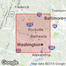
Mapped in District of Columbia and northward to vicinity of Bethesda, MD. Named from occurrence near Bear Island on the Potomac, [Montgomery Co.], MD.
Source: US geologic names lexicon (USGS Bull. 1200, p. 250).
- Usage in publication:
-
- Bear Island Granite
- Modifications:
-
- Redescribed
- Dominant lithology:
-
- Granite
- AAPG geologic province:
-
- Piedmont-Blue Ridge province
Summary:
The Bear Island is here renamed Granite because of its silicic composition and because its plagioclase is albite.
Source: GNU records (USGS DDS-6; Reston GNULEX).
- Usage in publication:
-
- Bear Island Granodiorite*
- Modifications:
-
- Areal extent
- AAPG geologic province:
-
- Piedmont-Blue Ridge province
Summary:
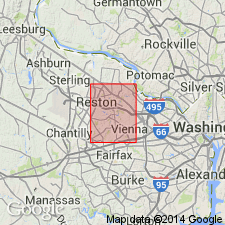
Bear Island Granodiorite of Cloos and Cooke (1953) is here accepted for use by the USGS. The composition is varied and the rocks have been called granodiorite, leucotonalite, adamellite, quartz diorite, quartz monzonite, and granite. This leucocratic granitoid rock forms dikes, sheets, and small, irregularly shaped intrusive bodies within the high-grade part of the Peters Creek Schist from Bear Island in the Potomac River south to the overlap of Mesozoic rocks in the Manassas quad., VA, to as far northeast as the Patuxent River in the Woodbine quad, MD. It was emplaced after the deformation and cooling off of Peters Creek Schist. Age is Ordovician(?). [Drake followed Hopson's usage and called the rocks Bear Island Granite in the Fairfax quad.]
Source: GNU records (USGS DDS-6; Reston GNULEX).
For more information, please contact Nancy Stamm, Geologic Names Committee Secretary.
Asterisk (*) indicates published by U.S. Geological Survey authors.
"No current usage" (†) implies that a name has been abandoned or has fallen into disuse. Former usage and, if known, replacement name given in parentheses ( ).
Slash (/) indicates name conflicts with nomenclatural guidelines (CSN, 1933; ACSN, 1961, 1970; NACSN, 1983, 2005, 2021). May be explained within brackets ([ ]).