The National Geologic Map Database is migrating to a new infrastructure. We apologize for any service disruptions during this process.
|
|---|


- Usage in publication:
-
- Bear Canyon sandstone member
- Modifications:
-
- Original reference
- Dominant lithology:
-
- Sandstone
- AAPG geologic province:
-
- San Joaquin basin
Summary:
Pg. 211 (fig. 5), pl. 3. Bear Canyon sandstone member of Kreyenhagen formation. Proposed for persistent sandstone occurring about one-third of distance above base of Kreyenhagen on southwest side of Butts Ranch syncline. Thickness 100 to 300 feet. Overlies an unnamed unit, 300 to 1,000 feet thick, of foraminiferal clay-shales and platy shales, with some interbedded sandstone and limestone, and a thin glauconitic sandstone at base. Unit is faunally equivalent to Canoas siltstone member in Coalinga district. Underlies an unnamed upper member 500 to 1,500 feet thick consisting of siliceous and calcareous foraminiferal platy shales and some limestone. Age is late Eocene.
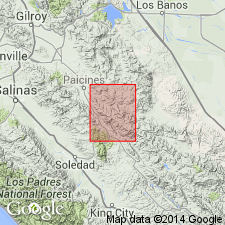
Type locality: Bear Canyon, 1 mi north of Big Oak Flat, San Benito Co., northern CA.
Source: US geologic names lexicon (USGS Bull. 1200, p. 249).
For more information, please contact Nancy Stamm, Geologic Names Committee Secretary.
Asterisk (*) indicates published by U.S. Geological Survey authors.
"No current usage" (†) implies that a name has been abandoned or has fallen into disuse. Former usage and, if known, replacement name given in parentheses ( ).
Slash (/) indicates name conflicts with nomenclatural guidelines (CSN, 1933; ACSN, 1961, 1970; NACSN, 1983, 2005, 2021). May be explained within brackets ([ ]).