The National Geologic Map Database is migrating to a new infrastructure. We apologize for any service disruptions during this process.
|
|---|


- Usage in publication:
-
- Bayne series
- Modifications:
-
- Original reference
- Dominant lithology:
-
- Shale
- Sandstone
- AAPG geologic province:
-
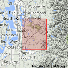
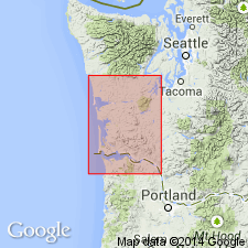
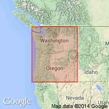
- Puget Sound province
Summary:
Pg. 42-49. Bayne series. Basal division of Puget formation in King County. Consists of sandstones and shales, with far greater percentage of shale than in overlying Franklin series. Some coal and bony beds. Age is Eocene.
Named from town of Bayne, King Co., central WA.
Source: US geologic names lexicon (USGS Bull. 896, p. 129).
- Usage in publication:
-
- Bayne member
- Modifications:
-
- Revised
- AAPG geologic province:
-
- Puget Sound province
Summary:
Bayne member (of Eocene of Green River Canyon, western Washington). Predominantly shales, with subordinate amounts of sandstone, shaly sandstone, and carbonaceous beds. Thickness 8,000 feet. Underlies Franklin member.
Source: US geologic names lexicon (USGS Bull. 896, p. 129).
- Usage in publication:
-
- Bayne formation
- Modifications:
-
- Revised
- AAPG geologic province:
-
- Puget Sound province
Summary:
Pg. 55, 56, 60. Bayne formation. Lowest formation of [Puget] group in Green River area. Consists of alternating strata of massive sandstone, shaly sandstone, sandy shale, alternating strata of massive sandstone, shaly sandstone, sandy shale, carbonaceous shale, and coal beds of varying degrees of purity. Thickness in Green River Canyon about 3,000 feet; base not exposed. Underlies Franklin formation; eastward from Green River Canyon, formation passes unconformably beneath Pleistocene lavas and tuffs. Formations in Green River Canyon are involved in anticlinal and synclinal folds whose axes trend northeast. Age is Eocene.
Source: US geologic names lexicon (USGS Bull. 1200, p. 243-244).
For more information, please contact Nancy Stamm, Geologic Names Committee Secretary.
Asterisk (*) indicates published by U.S. Geological Survey authors.
"No current usage" (†) implies that a name has been abandoned or has fallen into disuse. Former usage and, if known, replacement name given in parentheses ( ).
Slash (/) indicates name conflicts with nomenclatural guidelines (CSN, 1933; ACSN, 1961, 1970; NACSN, 1983, 2005, 2021). May be explained within brackets ([ ]).