

- Usage in publication:
-
- Bay de Noc member
- Modifications:
-
- Original reference
- Dominant lithology:
-
- Limestone
- AAPG geologic province:
-
- Michigan basin
Summary:
Pg. 113-150. Bay de Noc member of Stonington beds. Basal member of Stonington beds of Upper Ordovician Richmond formation. Basal part of member is massive-bedded, argillaceous limestone; upper or main part consists of argillaceous limestone in alternate, comparatively thin, hard and soft layers. Grayish brown to dark brown. Thickness about 38 feet. Rests disconformably on Bill's Creek beds and is conformably overlain by Ogontz member of Stonington beds. Age is Late Ordovician (Richmond).
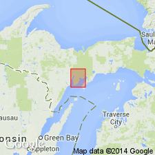
Chief exposure along eastern shore of Little Bay de Noc, from 1.5 mi north of Stratton's farm northward, and also south to Stonington Post Office, Delta Co., northern MI.
Source: US geologic names lexicon (USGS Bull. 896, p. 128).
- Usage in publication:
-
- Bay de Noc limestone
- Modifications:
-
- Revised
- AAPG geologic province:
-
- Michigan basin
Summary:
Chart 2 (column 40). Shown on correlation chart as Bay de Noc limestone underlying Ogontz limestone and overlying Bill's Creek shale. Age is Late Ordovician.
Source: US geologic names lexicon (USGS Bull. 1200, p. 242).
For more information, please contact Nancy Stamm, Geologic Names Committee Secretary.
Asterisk (*) indicates published by U.S. Geological Survey authors.
"No current usage" (†) implies that a name has been abandoned or has fallen into disuse. Former usage and, if known, replacement name given in parentheses ( ).
Slash (/) indicates name conflicts with nomenclatural guidelines (CSN, 1933; ACSN, 1961, 1970; NACSN, 1983, 2005, 2021). May be explained within brackets ([ ]).