

- Usage in publication:
-
- Bayard formation*
- Modifications:
-
- Original reference
- Dominant lithology:
-
- Sandstone
- Shale
- Limestone
- AAPG geologic province:
-
- Appalachian basin
Summary:
Bayard formation. A lower sandstone 196 feet thick; a middle division of shaly sandstone, shale, coal, and thin limestone 200 feet thick; and an upper sandstone, which is a beach deposit. Thickness 400 to 475 feet. Underlies Fairfax formation and overlies Savage formation. Age is Pennsylvanian.
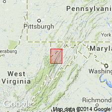
Exposed all around Bayard, Grant Co., northeastern WV. Extends into western MD.
[GNC remark (ca. 1936, US geologic names lexicon, USGS Bull. 896, p. 127): Corresponds to lower part of Conemaugh formation.]
Source: US geologic names lexicon (USGS Bull. 896, p. 127).
For more information, please contact Nancy Stamm, Geologic Names Committee Secretary.
Asterisk (*) indicates published by U.S. Geological Survey authors.
"No current usage" (†) implies that a name has been abandoned or has fallen into disuse. Former usage and, if known, replacement name given in parentheses ( ).
Slash (/) indicates name conflicts with nomenclatural guidelines (CSN, 1933; ACSN, 1961, 1970; NACSN, 1983, 2005, 2021). May be explained within brackets ([ ]).