

- Usage in publication:
-
- Battery formation
- Modifications:
-
- Original reference
- Dominant lithology:
-
- Sand
- AAPG geologic province:
-
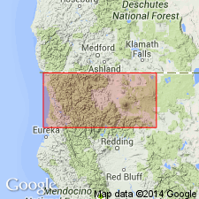
- Klamath Mountains province
Summary:
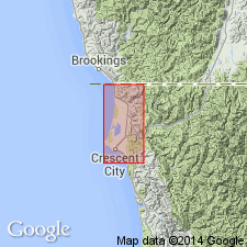
Pg. 136 and map. Battery formation. A thin marine terrace capping of unconsolidated sands exposed over south part of Crescent City platform. [Overlies St. George formation (Pliocene?) at Point St. George. In fault contact with Dothan formation (Jurassic).] A fossiliferous lens contains a small fauna whose general aspect is that of upper San Pedro [stage]. Age is Pleistocene.
[Named from Battery Point, southwest of Crescent City, Del Norte Co., northwestern CA.]
Source: US geologic names lexicon (USGS Bull. 896, p. 126); supplemental information from GNU records (USGS DDS-6; Menlo GNULEX), US geologic names lexicon (USGS Bull. 1200, p. 236-237).
- Usage in publication:
-
- Battery formation*
- Modifications:
-
- Revised
- Biostratigraphic dating
- AAPG geologic province:
-
- Klamath Mountains province
Summary:
Pg. 17 (table), 24-31, pl. 5. Battery formation, as mapped by Maxson (1933), included Holocene sand dunes along coast. These dunes are separately mapped in this report. Battery formation, as used in this report (Smith River plain, Del Norte County, northern California), includes related continental deposits consisting of contemporaneous stream gravels and elongate sand ridges. These ridges may not be of aqueous origin, but they are composed of reworked marine sediments and therefore are related to Battery formation. Thickness is as much as 66 feet; measured section at Pebble Beach is 28 feet. Where Pliocene sediments (St. George formation) remain, the Battery overlies them with slight unconformity. In rest of area, overlies Dothan formation (Jurassic) with angular unconformity. Underlies terrace deposits. Includes MACOMA INQUINATA Deshayes, SAXIDOMUS GIGANTEOS Deshayes, SPISULA sp., and BALANUS sp., collected by Hertlain who reports fossils suggest a Pleistocene age.
Source: US geologic names lexicon (USGS Bull. 1200, p. 236-237); GNU records (USGS DDS-6; Menlo GNULEX).
- Usage in publication:
-
- Battery Formation*
- Modifications:
-
- Age modified
- AAPG geologic province:
-
- Klamath Mountains province
Summary:
Battery Formation is believed to date from most recent Pleistocene interglaciation, Sangamon, when sea level was somewhat higher than it is now.
Source: GNU records (USGS DDS-6; Menlo GNULEX).
For more information, please contact Nancy Stamm, Geologic Names Committee Secretary.
Asterisk (*) indicates published by U.S. Geological Survey authors.
"No current usage" (†) implies that a name has been abandoned or has fallen into disuse. Former usage and, if known, replacement name given in parentheses ( ).
Slash (/) indicates name conflicts with nomenclatural guidelines (CSN, 1933; ACSN, 1961, 1970; NACSN, 1983, 2005, 2021). May be explained within brackets ([ ]).