

- Usage in publication:
-
- Batesville sandstone
- Modifications:
-
- Named
- Dominant lithology:
-
- Sandstone
- AAPG geologic province:
-
- Arkoma basin
Summary:
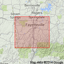
Batesville sandstone. Consists of a coarse, massive sandstone which varies in color from gray to brown; is 10 to 60 feet thick; usually forms beds 1 to 3, or 4 feet thick. Exposed in Washington County, Arkansas, in the Arkoma basin. In the bluff of Harp's Mountain, 8 miles northeast of Fayetteville, is a massive sandstone 60 feet thick. This sandstone bluff rises from the water's edge to a height of 30+ feet in SE/4 SE/4 sec. 32, T. 15 N., R. 30 W. Either immediately underlies the Archimedes [Pitkin] limestone (new), or is separated from it by the Marshall shale (new). Overlies Fayetteville shale (new). Age is Early Carboniferous. Report includes geologic map of Washington County, stratigraphic table, columnar sections.
Type locality not designated. [In a stratigraphic table shown on p. xiii of Introduction, J.C. Branner is credited with origin of this name.]
[According to US geologic names lexicon (USGS Bull. 896, p. 125), the sandstone above described in Washington County is now [ca. 1938] known not to be the Batesville but seems to be the Wedington sandstone member of Fayetteville shale. The true Batesville sandstone [= Simonds' (1891) †Wyman sandstone] is of Chester age, and at Batesville, it overlies Moorefield shale, or in its absence Boone limestone; and to west it underlies true Fayetteville shale.]
Source: Modified from GNU records (USGS DDS-6; Denver GNULEX).
- Usage in publication:
-
- Batesville sandstone*
- Modifications:
-
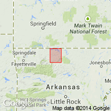
- Areal extent
- AAPG geologic province:
-
- Arkoma basin
Summary:
Batesville sandstone. Corrected the miscorrelations made in [Simonds' report (1891, Arkansas Geol. Survey Ann. Rpt. 1888, v. 4, p. 26, 42-49)], and described the following as correct stratigraphic succession (downward): Pitkin ("Archimedes") Iimestone; Wedington sandstone underlain by Fayetteville shale (= Marshall shale of Simonds); true Batesville sandstone (= sandstone exposed at type locality of Wyman sandstone); Moorefield shale (mistaken for Fayettevllle shale by Simonds); and Boone limestone; and stated that Wedington sandstone seems to be the sandstone called Batesville by Simonds.
Source: US geologic names lexicon (USGS Bull. 896, Fayetteville entry p. 725).
- Usage in publication:
-
- Batesville Sandstone
- Modifications:
-
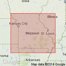
- Overview
- AAPG geologic province:
-
- Arkoma basin
Summary:
Pg. 23-24. Batesville Sandstone. In southwestern Missouri, usually a fine-grained, reddish sandstone. Overlies Hindsville Limestone or locally Keokuk Limestone; underlies Fayetteville Formation. Recognized in southeastern part of Cassville 15-min quadrangle, Barry County, Missouri (E.L. Clark, 1941, unpub. PhD thesis, Univ. Missouri-Columbia); in Newton County and possibly Greene County, southwestern Missouri; and in northern Pulaski County (T.L. Thompson and C.E. Robertson, 1993, Missouri Div. Geol. and Land Survey, Rpt. Inv., no. 71, Gdbk. no. 23, p. 15). Age is Late Mississippian (Chesterian). Report includes nomenclature history.
Source: Publication.
For more information, please contact Nancy Stamm, Geologic Names Committee Secretary.
Asterisk (*) indicates published by U.S. Geological Survey authors.
"No current usage" (†) implies that a name has been abandoned or has fallen into disuse. Former usage and, if known, replacement name given in parentheses ( ).
Slash (/) indicates name conflicts with nomenclatural guidelines (CSN, 1933; ACSN, 1961, 1970; NACSN, 1983, 2005, 2021). May be explained within brackets ([ ]).