The National Geologic Map Database is migrating to a new infrastructure. We apologize for any service disruptions during this process.
|
|---|


- Usage in publication:
-
- Baseline sandstone*
- Modifications:
-
- Original reference
- Dominant lithology:
-
- Sandstone
- AAPG geologic province:
-
- Great Basin province
Summary:
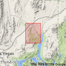
Pg. 929 (table 1), 932-933, pl. 5. Baseline sandstone. Friable sandstone, gray, reddish, and variegated. Contains many lenticular beds of conglomerate, some very coarse, especially in upper part. Change in textural character, together with the average higher coloration in upper part of section, is basis for dividing formation into two members. Maximum thickness of lower member about 2,000 feet; of upper member about 1,500 feet. Upper member restricted to a belt west of the Baseline fault; this member with part of lower member as well, eroded from eastern (upthrown) fault block. Overall thickness more than 3,000 feet. Underlies Overton fanglomerate with angular unconformity; overlies Willow Tank formation (new). Previously a part of Overton fanglomerate.
Exposed along Baseline Wash in Muddy Mountains, Clark Co., NV.
Source: US geologic names lexicon (USGS Bull. 1200, p. 228).
For more information, please contact Nancy Stamm, Geologic Names Committee Secretary.
Asterisk (*) indicates published by U.S. Geological Survey authors.
"No current usage" (†) implies that a name has been abandoned or has fallen into disuse. Former usage and, if known, replacement name given in parentheses ( ).
Slash (/) indicates name conflicts with nomenclatural guidelines (CSN, 1933; ACSN, 1961, 1970; NACSN, 1983, 2005, 2021). May be explained within brackets ([ ]).