

- Usage in publication:
-
- Barton limestone
- Modifications:
-
- Original reference
- Dominant lithology:
-
- Limestone
- AAPG geologic province:
-
- Appalachian basin (Eastern Overthrust area)
Summary:
Pg. 573. Barton limestone. Underlies Barton coal and overlies Upper Grafton sandstone; all included in Conemaugh formation. [Age is Pennsylvanian.]
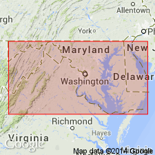
[Notable exposures in Allegany and Garrett Cos., western MD.]
Source: US geologic names lexicon (USGS Bull. 896, p. 121).
- Usage in publication:
-
- Barton limestone
- Modifications:
-
- Areal extent
- Dominant lithology:
-
- Limestone
- AAPG geologic province:
-
- Appalachian basin (Eastern Overthrust area)
Summary:
Pg. 115. Gave thickness of Barton limestone in Castleman basin as 5 feet and in Georges Creek basin as 1 foot.
Source: US geologic names lexicon (USGS Bull. 896, p. 121).
- Usage in publication:
-
- Barton limestone
- Modifications:
-
- Areal extent
- AAPG geologic province:
-
- Appalachian basin (Eastern Overthrust area)
Summary:
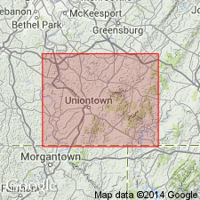
Pg. 96-97. In Fayette County, southwestern Pennsylvania, Barton limestone occurs 8 feet below Barton coal, which is separated from overlying Morgantown sandstone by 12 feet of black shale. Limestone is 3 feet thick, dark gray, knobby, and impure. Directly overlies Birmingham red shale. [Age is Pennsylvanian.]
Source: US geologic names lexicon (USGS Bull. 1200, p. 225-226).
- Usage in publication:
-
- Barton limestone
- Modifications:
-
- Areal extent
- AAPG geologic province:
-
- Appalachian basin (Eastern Overthrust area)
Summary:
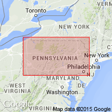
Pg. 69 (fig. 4). Barton limestone shown on generalized columnar section for Pennsylvanian of western Pennsylvania. Above upper Grafton sandstone and below Barton (Elk Lick) coal. Conemaugh series.
Source: US geologic names lexicon (USGS Bull. 1200, p. 225-226).
For more information, please contact Nancy Stamm, Geologic Names Committee Secretary.
Asterisk (*) indicates published by U.S. Geological Survey authors.
"No current usage" (†) implies that a name has been abandoned or has fallen into disuse. Former usage and, if known, replacement name given in parentheses ( ).
Slash (/) indicates name conflicts with nomenclatural guidelines (CSN, 1933; ACSN, 1961, 1970; NACSN, 1983, 2005, 2021). May be explained within brackets ([ ]).