The National Geologic Map Database is migrating to a new infrastructure. We apologize for any service disruptions during this process.
|
|---|


- Usage in publication:
-
- Bartholomew siltstone member*
- Modifications:
-
- Original reference
- Dominant lithology:
-
- Siltstone
- AAPG geologic province:
-
- Appalachian basin
Summary:
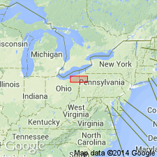
Pg. 1347, 1351, 1364; J.F. Pepper and others, 1954, USGS Prof. Paper 259, p. 18 (fig. 9), 42-43. Bartholomew siltstone member of Orangeville shale. Name proposed for gray or brownish-gray siltstone at or near base of Orangeville shale. Characterized by many short curved or curly markings which generally have a random distribution; in unweathered state, markings are darker than rest of siltstone. Thickness less than 1 foot. Occurs 8 feet above base of Orangeville at type locality; overlies Shellhammer Hollow formation (new) in some other areas. Age is Early Mississippian.
Type locality: Bartholomew quarry section, 1 mi northwest of Littles Corner on a small run, Hayfield Twp., Crawford Co., northwestern PA. Also occurs in Erie and Venango Cos.
Source: US geologic names lexicon (USGS Bull. 1200, p. 224).
For more information, please contact Nancy Stamm, Geologic Names Committee Secretary.
Asterisk (*) indicates published by U.S. Geological Survey authors.
"No current usage" (†) implies that a name has been abandoned or has fallen into disuse. Former usage and, if known, replacement name given in parentheses ( ).
Slash (/) indicates name conflicts with nomenclatural guidelines (CSN, 1933; ACSN, 1961, 1970; NACSN, 1983, 2005, 2021). May be explained within brackets ([ ]).