The National Geologic Map Database is migrating to a new infrastructure. We apologize for any service disruptions during this process.
|
|---|


- Usage in publication:
-
- Barnes conglomerate*
- Modifications:
-
- Original reference
- Dominant lithology:
-
- Conglomerate
- AAPG geologic province:
-
- Southwestern Basin-and-Range region
Summary:
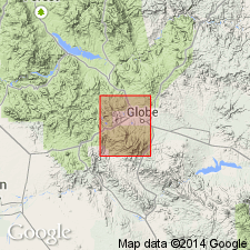
Barnes conglomerate of Apache group. Conglomerate, 10 to 15 feet thick, composed of well-rounded pebbles of hard white or pink quartzite with some reddish jasper and white vein quartz. Overlies Pioneer shale and underlies Dripping Spring quartzite. Forms a conspicuous girdle about Barnes Peak, Globe district, [Gila County], central Arizona. Included in Apache group. Age is pre-Cambrian.
Source: US geologic names lexicon (USGS Bull. 896, p. 115); supplemental information from GNU records (USGS DDS-6; Denver GNULEX).
- Usage in publication:
-
- Barnes conglomerate*
- Modifications:
-
- Age modified
- AAPG geologic province:
-
- Southwestern Basin-and-Range region
Summary:
Age of Apache group [which includes Barnes conglomerate] is accepted as Algonkian.
Source: Modified from GNU records (USGS DDS-6; Denver GNULEX).
- Usage in publication:
-
- Barnes conglomerate
- Modifications:
-
- Areal extent
- AAPG geologic province:
-
- Southwestern Basin-and-Range region
Summary:
Extended into Peppersauce Canyon in South Catalina Mountains where reported to be 37 feet thick. Age is Pre-Cambrian.
Source: Modified from GNU records (USGS DDS-6; Denver GNULEX).

- Usage in publication:
-
- Barnes conglomerate*
- Modifications:
-
- Overview
- AAPG geologic province:
-
- Southwestern Basin-and-Range region
Summary:
Mapped with Dripping Spring Quartzite, as part of Apache Group, in Dragoon quadrangle, Cochise County, Arizona, in Southwestern Basin-and-Range region. Measured sections described: (1) in NE/4 NW/4 sec. 21, T. 15 S., R. 22 E., where it is 26.5 feet thick, overlies a diabase and underlies Dripping Spring; and (2) in NW/4 sec. 26, T. 15 S., R. 22 E., where it overlies Barnes Conglomerate and underlies Dripping Spring. Age is late Precambrian.
Source: Modified from GNU records (USGS DDS-6; Denver GNULEX).
- Usage in publication:
-
- Barnes Conglomerate Member*
- Modifications:
-
- Revised
- AAPG geologic province:
-
- Southwestern Basin-and-Range region
Summary:
Reduced in rank and included as basal member of Dripping Spring Quartzite of Apache Group. Detailed lithologic description and twelve measured sections included. Thickness is irregular; ranges from 5 to 20 feet thick. Deposited as paleochannel fill and on top of Pioneer Formation. Age is late Precambrian.
Source: Modified from GNU records (USGS DDS-6; Denver GNULEX).
- Usage in publication:
-
- Barnes Conglomerate Member*
- Modifications:
-
- Areal extent
- Dominant lithology:
-
- Quartzite
- AAPG geologic province:
-
- Southwestern Basin-and-Range region
Summary:
Extended into Vekol and Slate Mountains, Arizona, in Southwestern Basin-and-Range region, as the basal member of the Dripping Spring Quartzite of the Apache Gorup. Is composed of 24 to 45 feet of conglomeratic quartzite; is intruded by diabase sills. Absent in the Waterman Mountains. Age is younger Precambrian
Source: Modified from GNU records (USGS DDS-6; Denver GNULEX).
- Usage in publication:
-
- Barnes Conglomerate Member*
- Modifications:
-
- Areal extent
- AAPG geologic province:
-
- Southern Rocky Mountain region
Summary:
Recognized in Chediski Peak quadrangle, Navajo County, Arizona, in the Southern Rocky Mountain region, as the basal member of the Dripping Spring Quartzite of the Apache Group. Is 8 to 30 feet thick. Overlies Pioneer Formation and underlies middle member of Dripping Spring. Age is late Precambrian.
Source: Modified from GNU records (USGS DDS-6; Denver GNULEX).
- Usage in publication:
-
- Barnes Conglomerate Member*
- Modifications:
-
- Overview
- AAPG geologic province:
-
- Southwestern Basin-and-Range region
Summary:
Described in Southwestern Basin-and-Range region, as basal member of the Dripping Spring Quartzite of the Apache Group. Is basal 18 feet of measured section in SW/4 SW/4 sec. 18, T. 5 N., R. 15 E., Gila County, Arizona. Where Pioneer pinches out, merges with Scanlan Conglomerate Member. Where Dripping Spring pinches out, is basal to the siltstone member. Age is younger Precambrian. Report includes detailed lithology.
Source: Modified from GNU records (USGS DDS-6; Denver GNULEX).
- Usage in publication:
-
- Barnes Conglomerate Member*
- Modifications:
-
- Age modified
- AAPG geologic province:
-
- Southwestern Basin-and-Range region
Summary:
Age modified from Precambrian to Precambrian Y age. Is basal member of Dripping Spring Formation of Apache Group in Cochise County, Arizona, in the Southwestern Basin-and-Range region.
Source: Modified from GNU records (USGS DDS-6; Denver GNULEX).
For more information, please contact Nancy Stamm, Geologic Names Committee Secretary.
Asterisk (*) indicates published by U.S. Geological Survey authors.
"No current usage" (†) implies that a name has been abandoned or has fallen into disuse. Former usage and, if known, replacement name given in parentheses ( ).
Slash (/) indicates name conflicts with nomenclatural guidelines (CSN, 1933; ACSN, 1961, 1970; NACSN, 1983, 2005, 2021). May be explained within brackets ([ ]).