

- Usage in publication:
-
- Bankston Fork limestone
- Modifications:
-
- Original reference
- Dominant lithology:
-
- Limestone
- AAPG geologic province:
-
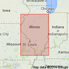
- Illinois basin
Summary:
Pg. 257, 261, 262. [Bankston Creek limestone in columnar section on p. 257; Bankston Fork limestone elsewhere in report.] The limestone which I have chosen to call Bankston Fork limestone lies in lower part of McLeansboro formation, about 40 feet above Herrin No. 6 coal, top member of underlying Carbondale formation. It is a fairly pure, slightly brownish or pinkish, hard, dense limestone, which commonly breaks with a fracture somewhat concoidal. Contains fossils. Thickness 0 to 15+ feet. Is discontinuous, possibly because locally displaced by Anvil Rock. The stratigraphic relation of these two strata is not very certain in mind of writer. One of best exposures is along south side of valley of Bankston Creek, just east of Saline County line, southeastern Illinois.
Source: US geologic names lexicon (USGS Bull. 896, p. 110).
- Usage in publication:
-
- Bankston Fork limestone member
- Modifications:
-
- Revised
- Dominant lithology:
-
- Limestone
- AAPG geologic province:
-
- Illinois basin
Summary:
Bankston Fork limestone member of McLeansboro formation. Argillaceous, dark blue, massive, fossiliferous limestone; weathers brown. Thickness 2.5 to 7 feet in Perry County, southwestern Illinois. Top lies 5 to 7 feet below Galum limestone member. Base lies 25+/- feet above Herrin (No. 6) coal. Named by G.H. Cady (Trans. Ill. Acad. Sci., v. 19, p. 261).
Source: US geologic names lexicon (USGS Bull. 896, p. 110).
- Usage in publication:
-
- Bankston Fork limestone
- Modifications:
-
- Overview
- AAPG geologic province:
-
- Illinois basin
Summary:
Pl. 1. Bankston Fork limestone. Included in Bankston cyclothem, McLeansboro group. On correlation chart, shown below Bankston coal and above Anvil Rock sandstone.
Source: US geologic names lexicon (USGS Bull. 1200, p. 211).

- Usage in publication:
-
- Bankston Fork limestone member
- Modifications:
-
- Principal reference
- Revised
- AAPG geologic province:
-
- Illinois basin
Summary:
Pg. 34, 35, 48 (table 1), pl. 1. Bankston Fork limestone member of Carbondale formation of Kewanee group (new). Reallocated to member status in Carbondale formation. Name Allenby coal member proposed for coal formerly called Bankston so that name may be restricted to Bankston Fork limestone. Stratigraphically above Anvil Rock sandstone member. Correlation chart shows Bankston Fork in western Kentucky. Type locality stated; location given by Cady (1926) incorrect. Age is Pennsylvanian. Report presents new rock-stratigraphic classification of Pennsylvanian strata in Illinois. Cyclical classification is retained but is independent of rock-stratigraphic classification.
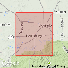
Type locality (corrected): [along Bankston Fork], in NE/4 NW/4 sec. 19, T. 9 S., R. 5 E., Harrisburg 7.5-min quadrangle, Saline Co., southern IL.
Source: Publication; US geologic names lexicon (USGS Bull. 1200, p. 211).
For more information, please contact Nancy Stamm, Geologic Names Committee Secretary.
Asterisk (*) indicates published by U.S. Geological Survey authors.
"No current usage" (†) implies that a name has been abandoned or has fallen into disuse. Former usage and, if known, replacement name given in parentheses ( ).
Slash (/) indicates name conflicts with nomenclatural guidelines (CSN, 1933; ACSN, 1961, 1970; NACSN, 1983, 2005, 2021). May be explained within brackets ([ ]).