The National Geologic Map Database is migrating to a new infrastructure. We apologize for any service disruptions during this process.
|
|---|


- Usage in publication:
-
- Bald Knoll formation
- Modifications:
-
- First used
- AAPG geologic province:
-
- Wasatch uplift
Summary:
Bald Knoll formation is recognized in Gunnison Co, UT. Age is late Eocene of early Oligocene.
Source: GNU records (USGS DDS-6; Menlo GNULEX).
- Usage in publication:
-
- Bald Knoll formation
- Modifications:
-
- Original reference
- Dominant lithology:
-
- Clay
- Siltstone
- Sandstone
- AAPG geologic province:
-
- Wasatch uplift
Summary:
Pg. 11 (table 1), 43-47, pl. 2; W.N. Gilliland, 1949, Ohio State Univ. Abs. Doctors' Dissert. 57, p. 71. Bald Knoll formation. Succession of light-green, light-tan, gray, and white clays with interbedded siltstone, sandstone, and minor amounts of soft limestone of the same colors. Thickness at type locality about 600 feet; elsewhere may be as much as 800 to 1,000 .feet. Underlies Axtell formation with angular discordance; overlies Crnzy Hollow formation. Age is late Eocene or early Oligocene.
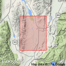
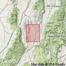
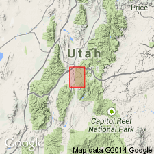
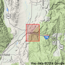
Type locality: at mouth of Bald Knoll Canyon in southern Valley Mountains, [in T. 21 S., R. 1 W., Redmond Canyon 7.5-min quadrangle], Sevier Co., central UT.
Source: US geologic names lexicon (USGS Bull. 1200, p. 201).
- Usage in publication:
-
- Bald Knoll formation
- Modifications:
-
- Revised
- Biostratigraphic dating
- AAPG geologic province:
-
- Wasatch uplift
Summary:
Exposures of the Bald Knoll formation northwest of Aurora, UT are considered to be equivalent to the basal part of the Gray Gulch formation on the basis of lithologic similarity. Bald Knoll has priority. Section measured on east and west side of Lost Creek from sec.1 to sec.11, T23S R1W [Rex Reservoir 7.5' quad, Sevier Co], is 1049.1 ft thick. Fossils [charophytes] suggest a tentative age or late Eocene or Oligocene.
Source: GNU records (USGS DDS-6; Menlo GNULEX).
- Usage in publication:
-
- Bald Knoll Formation†
- Modifications:
-
- Geochronologic dating
- Abandoned
- AAPG geologic province:
-
- Wasatch uplift
Summary:
Abandoned and replaced by informal "formation of Aurora." Study area is within Sevier Co, UT, Wasatch uplift. Mapping in Redmond Canyon and Aurora (UGMS Map 112) quads has shown that rocks at type section (Bald Knoll Wash, located about 5 mi northwest of Salina quad, in Redmond Canyon quad) are not equivalent to rocks mapped as Bald Knoll elsewhere in central Sevier Valley. In Aurora quad (USGS Map 112) same author states that type Bald Knoll is in area where unit is juxtaposed by a previously unrecognized fault against younger rocks of similar lithology; rocks at type of former Bald Knoll are actually Sevier River Formation of Miocene-Pliocene age; the unit will be considered informal until a new name and type is established. A K-Ar date on biotite from rhyolite tuff in lower part of formation of Aurora yielded an age of 40.5 +/-1.7 Ma; K-Ar dates from pumiceous units near top of unit in Aurora quad yielded ages of 39.6 +/-1.5 and 38.4 +/-1.5 Ma.
Source: GNU records (USGS DDS-6; Denver GNULEX).
For more information, please contact Nancy Stamm, Geologic Names Committee Secretary.
Asterisk (*) indicates published by U.S. Geological Survey authors.
"No current usage" (†) implies that a name has been abandoned or has fallen into disuse. Former usage and, if known, replacement name given in parentheses ( ).
Slash (/) indicates name conflicts with nomenclatural guidelines (CSN, 1933; ACSN, 1961, 1970; NACSN, 1983, 2005, 2021). May be explained within brackets ([ ]).