The National Geologic Map Database is migrating to a new infrastructure. We apologize for any service disruptions during this process.
|
|---|


- Usage in publication:
-
- Baker Pond gneiss
- Modifications:
-
- Original reference
- Dominant lithology:
-
- Gneiss
- AAPG geologic province:
-
- New England province
Summary:
(J.B. Hadley, 1938, Geologic map and structure sections of the New Hampshire portion of the Mt. Cube quadrangle).
Baker Pond gneiss in Oliverian magma series. Fine-grained gray gneiss, locally containing microcline phenocrysts. Largely quartz monzonite with some granodiorite. Border phase is dark-greenish-gray quartz diorite gneiss. Included in Oliverian magma series whose age is younger than Lower Devonian and is probably Upper Devonian. [Age of Oliverian Plutonic Suite has since been changed to Middle Ordovician.]
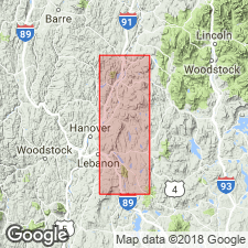
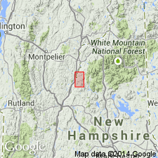
Mapped in the area around Upper Baker Pond, which is located on the border of the Mount Cube and Rumney quadrangles, west-central NH.
Source: US geologic names lexicon (USGS Bull. 1200, p. 196); supplemental information from GNU records (USGS DDS-6; Reston GNULEX).
- Usage in publication:
-
- Baker Pond Gneiss*
- Modifications:
-
- Areal extent
- AAPG geologic province:
-
- New England province
Summary:
Shown on accompanying geologic map northeast of Mt. Cube and east of Indian Pond pluton (Bethlehem Gneiss). Age is Ordovician. Consists of foliated granite.
Source: GNU records (USGS DDS-6; Reston GNULEX).
For more information, please contact Nancy Stamm, Geologic Names Committee Secretary.
Asterisk (*) indicates published by U.S. Geological Survey authors.
"No current usage" (†) implies that a name has been abandoned or has fallen into disuse. Former usage and, if known, replacement name given in parentheses ( ).
Slash (/) indicates name conflicts with nomenclatural guidelines (CSN, 1933; ACSN, 1961, 1970; NACSN, 1983, 2005, 2021). May be explained within brackets ([ ]).