The National Geologic Map Database is migrating to a new infrastructure. We apologize for any service disruptions during this process.
|
|---|


- Usage in publication:
-
- Baker member
- Modifications:
-
- Original reference
- Biostratigraphic dating
- Dominant lithology:
-
- Conglomerate
- Sandstone
- AAPG geologic province:
-
- Peninsular Ranges province
Summary:
Pg. 380. Baker member of Ladd formation. Briefly described in "Generalized section of formations in the Santa Ana Mountains, California." Is lower member (of 2) of Ladd formation. Consists of gray to brownish, massive to thick-bedded boulder conglomerate below, grading up into thick-bedded to shaly arkosic soft brown sandstone above. Sandstones at top highly fossiliferous. Thickness about 200 feet. Overlies Cretaceous(?) Trabuco formation; underlies Holz member (new) of Ladd formation. Age is Late Cretaceous based on molluscan fossils described in report.
Source: Publication; US geologic names lexicon (USGS Bull. 1200, p. 196); GNU records (USGS DDS-6; Menlo GNULEX).
- Usage in publication:
-
- Baker conglomerate member
- Modifications:
-
- Redescribed
- AAPG geologic province:
-
- Peninsular Ranges province
Summary:
Pg. 740. Referred to as Baker conglomerate member of Ladd formation. [Age is Late Cretaceous.]
Source: US geologic names lexicon (USGS Bull. 1200, p. 196).
- Usage in publication:
-
- Baker Canyon member
- Modifications:
-
- Principal reference
- Biostratigraphic dating
- Dominant lithology:
-
- Conglomerate
- Sandstone
- AAPG geologic province:
-
- Peninsular Ranges province
Summary:
Pg. 166, 168 (fig. 2), 170-171, 177 (fig. 3). Baker Canyon member of Ladd formation. Lower member (of 2) of Ladd. Previously called "Baker member" by Popenoe (1937) and "Baker conglomerate member" by Popenoe (1941). Renamed (Baker preoccupied). Consists of gray to brown, massive to thick-bedded boulder conglomerate below, grading up into thick-bedded to shaly arkosic soft brown sandstones above. Sandstones generally highly fossiliferous. Thickness averages 200 to 300 feet. Overlies Cretaceous(?) Trabuco formation; contact generally abrupt, but in places gradational. Underlies Holz shale member of Ladd formation. Age is Late Cretaceous based on molluscan fossils listed and described in report.
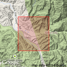
Type locality: Baker Canyon [Lat. 33 deg. 45 min. 42 sec. N., Long. 117 deg. 40 min. 31 sec. W., Black Star Canyon 7.5-min quadrangle] Orange Co., CA. Named from Baker Canyon.
Source: US geologic names lexicon (USGS Bull. 1200, p. 196); GNU records (USGS DDS-6; Menlo GNULEX).
- Usage in publication:
-
- Baker Canyon conglomerate member*
- Modifications:
-
- Adopted
- Redescribed
- Dominant lithology:
-
- Conglomerate
- AAPG geologic province:
-
- Peninsular Ranges province
Summary:
Adopted as Baker Canyon conglomerate member of Ladd formation. Age on map legend is Late Cretaceous.
Source: US geologic names lexicon (USGS Bull. 1200, p. 196); GNU records (USGS DDS-6; Menlo GNULEX).
For more information, please contact Nancy Stamm, Geologic Names Committee Secretary.
Asterisk (*) indicates published by U.S. Geological Survey authors.
"No current usage" (†) implies that a name has been abandoned or has fallen into disuse. Former usage and, if known, replacement name given in parentheses ( ).
Slash (/) indicates name conflicts with nomenclatural guidelines (CSN, 1933; ACSN, 1961, 1970; NACSN, 1983, 2005, 2021). May be explained within brackets ([ ]).