The National Geologic Map Database is migrating to a new infrastructure. We apologize for any service disruptions during this process.
|
|---|


- Usage in publication:
-
- Baga shale and limestone [unranked]
- Modifications:
-
- Original reference
- Biostratigraphic dating
- Dominant lithology:
-
- Limestone
- Shale
- Sandstone
- AAPG geologic province:
-
- Pedregosa basin
Summary:
Pg. 12, 36 (table 6). Baga shale and limestone [unranked] in Joserita member of Lowell formation of Bisbee group. Division 8e, dark-gray and greenish impure limestone in places lens shaped and grading laterally into white shale. Thickness 7 feet. Fossils (numerous lamellibranchs; ammonites, notably PARACANTHOHOPLITES MERIDIONALIS, gen. and sp. nov.). Age is Early Cretaceous (Aptian); PARAHOPLITES MELCHIORIS standard ammonite zone.
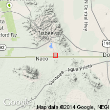
[Occurs in the Ninety One Hills area, local name for hills in secs. 14 and 23, T. 24 S., R. 24 E., immediately north of International border in vicinity of International Monument No. 91, southeast of Bisbee Junction on Southern Pacific RR, Bisbee 15-min quadrangle, Cochise Co., southeastern AZ. Area includes type locality and standard section of Lowell Formation.]
Source: Publication; US geologic names lexicon (USGS Bull. 1200, p. 192).
For more information, please contact Nancy Stamm, Geologic Names Committee Secretary.
Asterisk (*) indicates published by U.S. Geological Survey authors.
"No current usage" (†) implies that a name has been abandoned or has fallen into disuse. Former usage and, if known, replacement name given in parentheses ( ).
Slash (/) indicates name conflicts with nomenclatural guidelines (CSN, 1933; ACSN, 1961, 1970; NACSN, 1983, 2005, 2021). May be explained within brackets ([ ]).