The National Geologic Map Database is migrating to a new infrastructure. We apologize for any service disruptions during this process.
|
|---|


- Usage in publication:
-
- Badger Creek Tuff*
- Modifications:
-
- Original reference
- Dominant lithology:
-
- Tuff
- AAPG geologic province:
-
- Denver basin
Summary:
Pg. C13-C15. Badger Creek Tuff. A compound-cooling unit consisting of at least six ash flows. Previously called tuff of Badger Creek. Is light-gray to reddish-brown tuff; weathers yellowish-gray to buff. Has a salt-and-pepper appearance due to abundance of black biotite and hornblende crystals mixed with light-pink and white pumice lapilli. Thickness 313 feet at type locality; locally as much as 800 feet. Is nearly equivalent to Antero Formation. Rests on Precambrian crystalline rocks, Wall Mountain Tuff, or Tallahassee Creek Conglomerate. Is overlain by a local latite flow. Has reverse remanent magnetic polarity. Age is Oligocene.
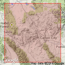
Type locality: in valley of East Badger Creek, in NE/4 sec. 12, T. 50 N., R. 10 E., 17.7 km northeast of Salida, Cameron Mountain quadrangle, Fremont Co., central CO.
Source: US geologic names lexicon (USGS Bull. 1200, p. 15); GNU records (USGS DDS-6; Denver GNULEX).
- Usage in publication:
-
- Badger Creek Tuff*
- Modifications:
-
- Revised
- AAPG geologic province:
-
- South Park basin
Summary:
Intertongues with Antero Formation (as revised in this report is equivalent to only the middle part of Johnson's (1937) Antero). In the South Park basin. Assigned an Oligocene age.
Source: GNU records (USGS DDS-6; Denver GNULEX).
- Usage in publication:
-
- Badger Creek Tuff*
- Modifications:
-
- Geochronologic dating
- AAPG geologic province:
-
- Eagle basin
Summary:
Pg. 16, geologic time scale (inside front cover). Badger Creek Tuff. An andesitic ash-flow tuff, underlies Buffalo Peaks Andesite and overlies Wall Mountain Tuff. Sample from Lat. 38 deg. 49 min. 20 sec. N., Long. 105 deg. 56 min. W., in NE/4 NE/4 sec. 22, T. 14 S., R. 77 W., Antero Reservoir 15-min quadrangle, Chaffee County, Colorado. [K-Ar] age on hornblende 37.4 +/-0.7 Ma; on biotite 36.3 +/-0.9 Ma. Decay constants of Steiger and Jager, 1977 (Earth Planet. Sci. Letters, v. 36, p. 359-362) are used. [Age is close to Eocene-Oligocene boundary, 36.6 (38 to 34) Ma (from Geologic Names Committee, USGS, 1983 ed. geol. time scale, with additions from N.J. Snelling, 1985, The Geol. Soc. Mem., no. 10).]
Source: Publication.
For more information, please contact Nancy Stamm, Geologic Names Committee Secretary.
Asterisk (*) indicates published by U.S. Geological Survey authors.
"No current usage" (†) implies that a name has been abandoned or has fallen into disuse. Former usage and, if known, replacement name given in parentheses ( ).
Slash (/) indicates name conflicts with nomenclatural guidelines (CSN, 1933; ACSN, 1961, 1970; NACSN, 1983, 2005, 2021). May be explained within brackets ([ ]).