

- Usage in publication:
-
- Bad limestone
- Modifications:
-
- Original reference
- Dominant lithology:
-
- Limestone
- AAPG geologic province:
-
- Wisconsin arch
Summary:
Pg. 338. Bad limestone. Cherty limestone, of lower Huronian age. Unconformably underlies Palms formation and unconformably overlies Archean granite and gneiss in Penokee-Gogebic district.
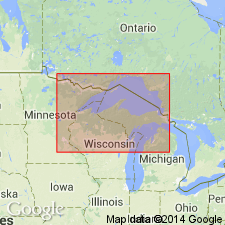
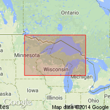
[Named from occurrence at Bad River, in Penokee Gap section, Penokee-Gogebic district, northwestern WI. Extends into northwestern MI.]
Source: US geologic names lexicon (USGS Bull. 896, p. 100).
- Usage in publication:
-
- Bad River formation
- Modifications:
-
- Revised
- AAPG geologic province:
-
- Wisconsin arch
Summary:
Btw. pgs. 680 and 695. Bad River formation of Gogebic Range is = Kona dolomite and Randville dolomite.
Source: US geologic names lexicon (USGS Bull. 896, p. 100).
- Usage in publication:
-
- Bad River limestone
- Modifications:
-
- Principal reference
- AAPG geologic province:
-
- Lake Superior region
Summary:
Pg. 225, 228. Bad River limestone. Chiefly limestone, heavily magnesian, in places approaching dolomite, intermingled and interstratified with chert. Thickness 200 to 300 feet. Grades into underlying Sunday quartzite. Top eroded. Underlies Palms formation. Age Precambrian (lower Huronian).
Named from occurrence at Bad River, in Penokee Gap section, Penokee-Gogebic district, northwestern WI. Extends into northwestern MI.
Source: US geologic names lexicon (USGS Bull. 896, p. 100).

- Usage in publication:
-
- Bad River dolomite*
- Modifications:
-
- Adopted
- AAPG geologic province:
-
- Wisconsin arch
Summary:
Adopted Bad River dolomite as the name of this formation. [Present in Gogebic district, northern Michigan.]
Source: US geologic names lexicon (USGS Bull. 896, p. 100).
- Usage in publication:
-
- Bad River dolomite*
- Modifications:
-
- Revised
- AAPG geologic province:
-
- Lake Superior region
Summary:
Pg. 85 (table 1). Bad River dolomite. Included in Animikie series. Overlies Sunday quartzite; underlies Palms quartzite with unconformity. Age is Precambrian (Animikie Series).
Source: US geologic names lexicon (USGS Bull. 1200, p. 191).
- Usage in publication:
-
- Bad River Dolomite*
- Modifications:
-
- Overview
- AAPG geologic province:
-
- Lake Superior region
Summary:
Pg. 2845 (fig. 2, stratigraphic chart compiled from Leith and others, 1935; James, 1958; Gair and Thaden, 1968). Bad River Dolomite of Chocolay Group of Marquette Range Supergroup (new; replaces †Animikie series of James, 1958, south of Lake Superior, in Michigan and Wisconsin). Present in Gogebic Range, northwestern Michigan. Overlies Sunday Quartzite of Chocolay Group; unconformably underlies Palms Quartzite of Menominee Group. Age is middle Precambrian.
Source: Publication.
For more information, please contact Nancy Stamm, Geologic Names Committee Secretary.
Asterisk (*) indicates published by U.S. Geological Survey authors.
"No current usage" (†) implies that a name has been abandoned or has fallen into disuse. Former usage and, if known, replacement name given in parentheses ( ).
Slash (/) indicates name conflicts with nomenclatural guidelines (CSN, 1933; ACSN, 1961, 1970; NACSN, 1983, 2005, 2021). May be explained within brackets ([ ]).