The National Geologic Map Database is migrating to a new infrastructure. We apologize for any service disruptions during this process.
|
|---|


- Usage in publication:
-
- Aycross formation*
- Modifications:
-
- Original reference
- Dominant lithology:
-
- Clay
- Tuff
- Shale
- Sandstone
- Conglomerate
- AAPG geologic province:
-
- Wind River basin
Summary:
Pg. 10, 11 (fig. 2), 66-73, pl. 17. Aycross formation. Proposed for middle Eocene sequence lying unconformably upon all older rocks from Precambrian to early Eocene and which is unconformably overlain by strata of late Eocene age. Consists of variegated clays, acidic andesite tuffs, conglomerates, and bentonite beds. Changes in physical appearance rapidly in short distances. Thickness at type locality about 1,000 feet; in some areas less than 100 feet. In type area, formation was deposited on a surface of high relief cut in folded and faulted rocks. In places there is angular discordance of 90 degrees with underlying strata, whereas in adjacent localities only a few miles distant there is only slight erosional unconformity. Shown on columnar section as unconformably underlying Tepee Trail formation (new) and unconformably overlying Wind River formation. Fossiliferous (vertebrates). Age is middle Eocene. Report includes geologic map.
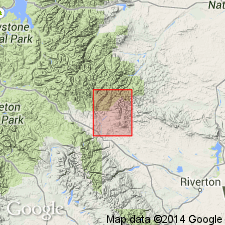
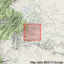
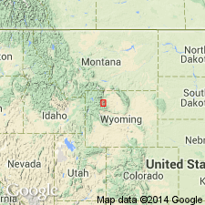
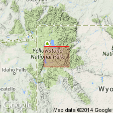
Type area: north side of North Mesa [now Upper Table], about 1 mi southeast of A Cross Ranch, in secs. 7, 8, 17, and 18, T. 7 N., R. 5 W., Fremont Co., southern Absaroka Range, Wind River Indian Reservation, northwestern WY. Named from A Cross Ranch on East Fork River at Duncan.
Source: US geologic names lexicon (USGS Bull. 1200, p. 181-182).
- Usage in publication:
-
- Aycross formation*
- Modifications:
-
- Areal extent
- AAPG geologic province:
-
- Bighorn basin
Summary:
Pg. 1880, 1892-1896. Aycross formation. West and south of Anchor Post Office, Masursky (Wyoming Geol. Assoc. Gdbk., 7th Ann. Field Conf., map, 1952) mapped beds equivalent to Pitchfork formation (new) as Aycross. He showed Aycross strata extending as far south as Owl Creek Range, where, on axis of range, they pinch out between limestone of Paleozoic age and Tepee Trail formation. It is believed that use of Aycross for these beds is misleading, as beds considered Aycross in Bighorn basin may never have been continuous with beds of Aycross south of Owl Creek Range, in Wind River basin. As used here, Pitchfork formation includes beds in Bighorn basin named Aycross by Masursky.
Source: US geologic names lexicon (USGS Bull. 1200, p. 181-182).
- Usage in publication:
-
- Aycross Formation*
- Modifications:
-
- Geochronologic dating
- Biostratigraphic dating
- AAPG geologic province:
-
- Yellowstone province
Summary:
Pg. 27-28, pl. 5. Aycross Formation. Notable exposures in North Mesa [Upper Table] (type area), Castle Rock, and East Fork River, northwestern Wyoming. In type area, contains middle Eocene (Bridgerian of Wood and others, 1941, GSA Bull., v. 52, no. 1) vertebrate fossils and in basal part, Kisinger Lakes pollen flora horizon. Sample from 232 feet above Kisinger Lakes horizon yielded a K-Ar age (biotite) of 49.2 +/-0.5 Ma (J.D. Obradovich, written commun., 1975). Underlies Tepee Trail Formation; overlies Wind River Formation or pre-Eocene rocks. Correlates with Hominy Peak Formation (new) of Absaroka Volcanic Supergroup. In Togwotee Pass area, Tepee Trail Formation of Smedes and Prostka (1972, USGS Prof. Paper 729-C) and Rohrer (in MacGinitie, 1974, California Univ. Pubs. Geol. Sci., v. 108) is more likely correlative entirely or in large part with the Aycross, based on K-Ar ages, pollen, vertebrate fossils, and lithology, and should not be called Tepee Trail. Report includes geologic map, measured section, correlation diagram.
Source: Publication.
- Usage in publication:
-
- Aycross Formation*
- Modifications:
-
- Revised
- Biostratigraphic dating
- Geochronologic dating
- AAPG geologic province:
-
- Bighorn basin
Summary:
Pg. 14-19, geol. map. Aycross Formation, basal formation of Thorofare Creek Group of Absaroka Volcanic Group. Characterized by rapid facies changes. Divisable into 5 sequences (ascending): (1) volcanic mudstone, volcanic sandstone, tuff, shale, and conglomerate, 30 m; (2) variegated fine-grained volcanic sandstone, siltstone, and tuff, 60 m; (3) variegated bentonitic mudstone, volcanic sandstone, and conglomerate, 80 m; (4) variegated siltstone, shale, and fine-grained volcanic sandstone, 60 m; and (5) bentonitic mudstone, volcanic conglomerate, and volcanic sandstone, 70 m. Includes most of Hay's (1956) †Pitchfork Formation (abandoned). Thickness about 290 m, thins to north. Unconformably overlies Willwood Formation; unconformably or disconformably underlies Tepee Trail Formation. Sample from tuff exposed at Duncan Ranch, near Aycross type area, recalibrated from 49.2 +/-0.5 Ma to 50.4 +/-0.5 Ma (J.D. Obradovich, oral commun., 1979). Fossiliferous (vertebrates, mollusks, plants). Age is middle Eocene (Bridgerian "A" and "B"). Study area in southeast Absaroka Range and southwest Bighorn basin, Hot Springs County, northwestern Wyoming. Report includes geologic map, cross sections, correlation diagram, systematic paleontology.
Source: Publication.
- Usage in publication:
-
- Aycross Formation
- Modifications:
-
- Areal extent
- AAPG geologic province:
-
- Bighorn basin
Summary:
Aycross and Wapiti Formations are lateral and time equivalents. The geographic boundary between these formations is in the Francs Fork-Timber Creek area, Absaroka Range, in T. 47 N., R. 103 W., southeastern Park County, Wyoming. Aycross recognized to the south and Wapiti to the north. In area of Carter Mountain, Aycross-like beds mapped with Wapiti. Unconformably overlies Willwood Formation and underlies Tepee Trail Formation.
Source: Modified from GNU records (USGS DDS-6; Denver GNULEX).
- Usage in publication:
-
- Aycross Formation*
- Modifications:
-
- Revised
- Mapped
- AAPG geologic province:
-
- Wind River basin
Summary:
Pg. 6, pl. 1. Aycross Formation, a fine-grained volcaniclastic sequence present only along the southeast margin of the report area. Consists of gray, pink, green, and black bentonitic claystone, thin carbonaceous shale and coal beds, green hard slabby tuffaceous sandstone, volcanic conglomerate, and hard siliceous white leaf-bearing tuff; locally abundant fresh-water mollusks, ostracodes, and pollen of middle Eocene age. Has K-Ar age of 47.8 +/-3 Ma (J.D. Obradovich in Smedes and Prostka, 1972, USGS Prof. Paper 729-C). Thickness 0 to 100 feet (0 to 30 m). In this report, the Aycross Formation is not assigned to either Sunlight or Thorofare Creek Group nor is it considered part of the Absaroka Volcanic Supergroup. Report includes geologic map.
Source: Publication.
For more information, please contact Nancy Stamm, Geologic Names Committee Secretary.
Asterisk (*) indicates published by U.S. Geological Survey authors.
"No current usage" (†) implies that a name has been abandoned or has fallen into disuse. Former usage and, if known, replacement name given in parentheses ( ).
Slash (/) indicates name conflicts with nomenclatural guidelines (CSN, 1933; ACSN, 1961, 1970; NACSN, 1983, 2005, 2021). May be explained within brackets ([ ]).