The National Geologic Map Database is migrating to a new infrastructure. We apologize for any service disruptions during this process.
|
|---|


- Usage in publication:
-
- Axtell formation
- Modifications:
-
- Original reference
- Dominant lithology:
-
- Conglomerate
- AAPG geologic province:
-
- Wasatch uplift
Summary:
Pg. 38, geol. map. Axtell formation. Youngest bedrock in area. Conglomerate containing pebbles, cobbles, and boulders of all other bedrock formations including lava. At type locality, conglomerate is 50 to 75 feet thick and dips northward about 21 deg. in an angular unconformity over west-dipping Green River limestone. Age is probably late Tertiary.
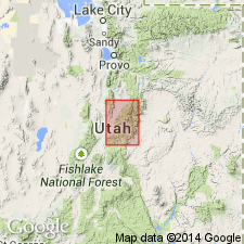
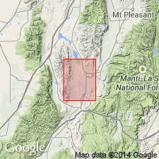
Type locality: stretch about 2 mi east of Axtell on eastern margin of Sevier Valley between abandoned plant of Great Western Salt Company (now abandoned) and Willow Creek, [in secs. 22 and 27, T. 20 S., R. 1 E., Redmond 7.5-min quadrangle, Sanpete Co.], central UT.
Source: US geologic names lexicon (USGS Bull. 1200, p. 181).
- Usage in publication:
-
- Axtell formation
- Modifications:
-
- Areal extent
- Age modified
- AAPG geologic province:
-
- Wasatch uplift
Summary:
Pg. 11 (table 1), 50-52, pl. 2; Ohio State Univ. PhD dissert. abs., no. 57, p. 71, 72, 1949. Axtell formation. In some nreas in Gunnison quadrangle, overlies Bald Knoll formation (new) with angular unconformity, and in some areas overlies unnamed pyroclastics and associated sediments with angular discordance. Spieker tentatively assigned Axtell to late Pliocene or early Pleistocene because it is obviously younger than all bedrock in region. Mapped as Pliocene.
Source: US geologic names lexicon (USGS Bull. 1200, p. 181).
For more information, please contact Nancy Stamm, Geologic Names Committee Secretary.
Asterisk (*) indicates published by U.S. Geological Survey authors.
"No current usage" (†) implies that a name has been abandoned or has fallen into disuse. Former usage and, if known, replacement name given in parentheses ( ).
Slash (/) indicates name conflicts with nomenclatural guidelines (CSN, 1933; ACSN, 1961, 1970; NACSN, 1983, 2005, 2021). May be explained within brackets ([ ]).