The National Geologic Map Database is migrating to a new infrastructure. We apologize for any service disruptions during this process.
|
|---|


- Usage in publication:
-
- Aura Formation
- Modifications:
-
- Original reference
- Dominant lithology:
-
- Phyllite
- Chert
- Limestone
- AAPG geologic province:
-
- Great Basin province
Summary:
Pg. 17-18, 36 (table 1), pI. 1. Aura Formation. Upper portion composed of thin-bedded brown to black phyllite and chert alternating with thick blue-gray limestone layers; middle member of 500 feet of buff medium-grained quartzite often missing; lower part similar to upper member with fewer and thinner limestone layers. Thickness about 3,800 feet, uncertain because of faulting and intrusive igneous stocks. Overlies Porter Peak Limestone (new); underlies Chellis Limestone (new), both contacts conformable. Age is tentatively Ordovician, based on regional correlation.
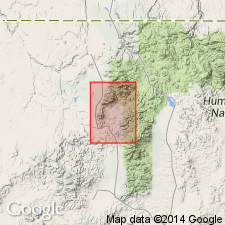
Named from Aura (Columbia) mining district on east slope Bull Run Mountains, [Bull Run 15-min quadrangle], Elko Co., northeastern NV. Formation exposed in undulating band trending east-west across Bull Run Mountains south of Blue Jacket Peak; continuity disrupted by intrusion of White Rock stock and by faulting which offsets part of formation.
Source: US geologic names lexicon (USGS Bull. 1350, p. 36).
For more information, please contact Nancy Stamm, Geologic Names Committee Secretary.
Asterisk (*) indicates published by U.S. Geological Survey authors.
"No current usage" (†) implies that a name has been abandoned or has fallen into disuse. Former usage and, if known, replacement name given in parentheses ( ).
Slash (/) indicates name conflicts with nomenclatural guidelines (CSN, 1933; ACSN, 1961, 1970; NACSN, 1983, 2005, 2021). May be explained within brackets ([ ]).