

- Usage in publication:
-
- Asphaltum sandstone
- Modifications:
-
- Original reference
- Dominant lithology:
-
- Sandstone
- AAPG geologic province:
-
- South Oklahoma folded belt
Summary:
Pg. 10+. Asphaltum sandstone. A series of gray to buff, yellow, calcareous sandstones, generally massive, friable, and medium-grained but locally laminated and thin-bedded, separated by shale beds. Thickness 20 to 50+ feet. Underlies Claypool formation. [On cross section lies 200+/- feet higher than Oscar sandstone.] Age is Pennsylvanian.
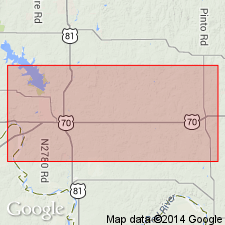
Is exposed in vicinity of town of Asphaltum, Jefferson Co., central southern OK.
Source: US geologic names lexicon (USGS Bull. 896, p. 83-84).
- Usage in publication:
-
- Asphaltum sandstone
- Modifications:
-
- Areal extent
- AAPG geologic province:
-
- South Oklahoma folded belt
Summary:
Pg. 1-2, 4-5. Asphaltum sandstone. Discussion of occurrence of radioactive material in sandstone lenses of southwestern Oklahoma. These sandstone lenses are associated with a crossbedded bituminous gray sandstone shown on Geologic Map of Oklahoma (Miser, 1954). Age of sandstone is given by Miser as probably equal to that of base of Garber sandstone of northern Oklahoma. Crossbedded bituminous sandstone was mapped in Cotton County and part of Tillman County as upper part of Auger conglomerate in upper part of Wichita formation by Munn (1914). Auger conglomerate extends from Cotton County into Jefferson County where it was mapped by Bunn (1930) as Ryan-Asphaltum sandstone. Crossbedded bituminous gray sandstone occurs in upper part of Asphaltum sandstone. Ryan sandstone is almost entirely crossbedded dark-gray sandstone. Age is Pennsylvanian.
Source: US geologic names lexicon (USGS Bull. 1200, p. 156).
For more information, please contact Nancy Stamm, Geologic Names Committee Secretary.
Asterisk (*) indicates published by U.S. Geological Survey authors.
"No current usage" (†) implies that a name has been abandoned or has fallen into disuse. Former usage and, if known, replacement name given in parentheses ( ).
Slash (/) indicates name conflicts with nomenclatural guidelines (CSN, 1933; ACSN, 1961, 1970; NACSN, 1983, 2005, 2021). May be explained within brackets ([ ]).