The National Geologic Map Database is migrating to a new infrastructure. We apologize for any service disruptions during this process.
|
|---|


- Usage in publication:
-
- Ashishik basalt*
- Modifications:
-
- Original reference
- Dominant lithology:
-
- Tuff
- Volcaniclastics
- Volcanics
- AAPG geologic province:
-
- Aleutian Islands province
- Alaska Southwestern region
Summary:
Pg. 25, 27, 38, pl. 3. Ashishik basalt. Consists of a sequence of massive basalt flows with minor interbedded tuff-breccia and tuff; individual flows range in thickness from 20 to 60 feet. Thickness 500 feet thick measured on cliff west of New Jersey Creek, 1.5 mi above mouth of creek, but base not exposed. [Unconformably] underlies (locally) Crater Creek basalt, Tanak volcanics, and Okmok ash (all new), and alluvium. Age is Tertiary and Quaternary [based on regional stratigraphic relations].
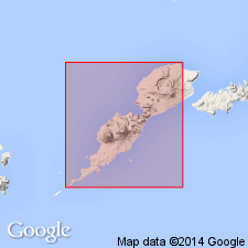
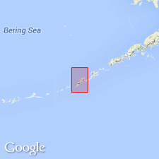
[Named from Ashishik Point at northernmost part of Umnak Island, Lat. 53 deg. 33 min. 34 sec. N., Long. 168 deg. 04 min. 44 sec. W., east-central part of Umnak 1:250,000 quadrangle, Aleutian Islands, southwestern AK.] Notable exposures in east-facing cliff west of New Jersey Creek, 2 to 3 mi south of Ashishik Point. Occurs on flanks of Okmok Volcano and in walls of Okmok caldera.
Source: US geologic names lexicon (USGS Bull. 1200, p. 150-151); GNU records (USGS DDS-6; Menlo GNULEX).
- Usage in publication:
-
- Ashishik basalt*
- Modifications:
-
- Principal reference
- Revised
- AAPG geologic province:
-
- Aleutian Islands province
- Alaska Southwestern region
Summary:
Pg. 309-311, pl. 41. Ashishik basalt. Is stratigraphically and geographically extended to include: (1) that part of (previously mapped) Crater Creek basalt occurring on outer flanks of Okmok Volcano, (2) that part of (previously mapped) Idak basalt not forming mass of Mount Idak, and (3) (previously unassigned) "basalt flows of Hill 1200" as mapped by Byers and others (1947). Consists of mafic phenocryst basalt, palagonitized pyroclastic rocks, and non-porphyritic feldspathic basalt. Overlies [unconformably] unnamed volcanic rocks; underlies [unconformably] (locally) unnamed volcanic rocks and Crater Creek basalt. Age is given as Tertiary and Quaternary.
Type locality: in east-facing cliff of prominent ridge west of New Jersey Creek, 2 to 3 mi south of Ashishik Point at northernmost part of Umnak Island, in east-central part of Umnak 1:250,000 quadrangle, Aleutian Islands, southwestern AK.
Source: US geologic names lexicon (USGS Bull. 1200, p. 150-151); GNU records (USGS DDS-6; Menlo GNULEX).
For more information, please contact Nancy Stamm, Geologic Names Committee Secretary.
Asterisk (*) indicates published by U.S. Geological Survey authors.
"No current usage" (†) implies that a name has been abandoned or has fallen into disuse. Former usage and, if known, replacement name given in parentheses ( ).
Slash (/) indicates name conflicts with nomenclatural guidelines (CSN, 1933; ACSN, 1961, 1970; NACSN, 1983, 2005, 2021). May be explained within brackets ([ ]).