

- Usage in publication:
-
- Arvison formation
- Modifications:
-
- Original reference
- Biostratigraphic dating
- Dominant lithology:
-
- Agglomerate
- Breccia
- Conglomerate
- AAPG geologic province:
-
- Klamath Mountains province
Summary:
Pg. 6, 11-14, pl. 1; Stanford Univ. Abs. Dissert., v. 27, p. 436-437 [1953]. Arvison formation. Proposed for series of dominantly pyroclastic (agglomerate, volcanic breccia, and conglomerate) beds with minor andesitic flows, which are intermediate between Modin and Potem formations and which do not appear to be continuous with Bagley andesite of Diller. Bagley andesite, as traced from its type area into Big Bend region, overlies and is interfingered with basal beds of Potem formation. Because basal strata of Potem appear to lie between Bagley andesite and Arvison pyroclastic accumulations, new name is proposed for the lower beds. Estimated thickness 5,090 feet in type area. Overlies Kosk member (new) of Modin formation. Underlies Potem formation; contact not exposed, inferred to be gradational. East of Kosk Creek underlies Tertiary lavas. Fossils. Age is Early Jurassic, based on ammonites and pectens.
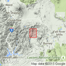
Type area: extends from point on Kosk Creek about 1.75 mi south of Arvison Flat to point about 1 mi north of Arvison Flat at contact with underlying Triassic beds, Big Bend 15-min quadrangle, [Shasta National Forest], Shasta Co., northern CA. Can be traced into adjacent Shoeinhorse Mountain 15-min quadrangle.
Named from Arvison Flat on Kosk Creek, [in sec. 12, T. 37 N., R. 1 W., approx. Lat. 41 deg. 04 min. 12 sec. N., Long. 121 deg. 55 min. 29 sec. W., Big Bend 7.5-min quadrangle, Shasta National Forest], Shasta Co., northern CA.
Source: US geologic names lexicon (USGS Bull. 1200, p. 146); GNU records (USGS DDS-6; Menlo GNULEX).
- Usage in publication:
-
- Arvison Formation*
- Modifications:
-
- Age modified
- AAPG geologic province:
-
- Klamath Mountains province
Summary:
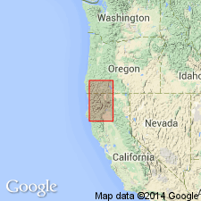
Arvison Formation of Sanborn (1960) is mapped in Big Bend area, southeastern Klamath Mountains, Shasta Co, CA. Age is probably Sinemurian and early Pliensbachian (Sanborn, 1960).
Source: GNU records (USGS DDS-6; Menlo GNULEX).
For more information, please contact Nancy Stamm, Geologic Names Committee Secretary.
Asterisk (*) indicates published by U.S. Geological Survey authors.
"No current usage" (†) implies that a name has been abandoned or has fallen into disuse. Former usage and, if known, replacement name given in parentheses ( ).
Slash (/) indicates name conflicts with nomenclatural guidelines (CSN, 1933; ACSN, 1961, 1970; NACSN, 1983, 2005, 2021). May be explained within brackets ([ ]).