The National Geologic Map Database is migrating to a new infrastructure. We apologize for any service disruptions during this process.
|
|---|


- Usage in publication:
-
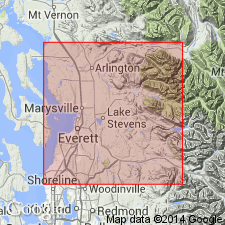
- Arlington gravel member*
- Modifications:
-
- Named
- Dominant lithology:
-
- Sand
- Gravel
- AAPG geologic province:
-
- Puget Sound province
Summary:
Named as Arlington gravel member of Vashon drift in area (T31-32N R5-6E) of western Snohomish Co, WA in eastern part of Puget Lowland. Composed of an outwash deposit of sand and gravel forming thin veneer over a terrace cut mainly in the earlier Stillaguamish sand member (new) of Vashon drift. Underlies Marysville sand member (new) of Vashon drift. Map legend shows age as Pleistocene.
Source: GNU records (USGS DDS-6; Menlo GNULEX).
For more information, please contact Nancy Stamm, Geologic Names Committee Secretary.
Asterisk (*) indicates published by U.S. Geological Survey authors.
"No current usage" (†) implies that a name has been abandoned or has fallen into disuse. Former usage and, if known, replacement name given in parentheses ( ).
Slash (/) indicates name conflicts with nomenclatural guidelines (CSN, 1933; ACSN, 1961, 1970; NACSN, 1983, 2005, 2021). May be explained within brackets ([ ]).