

- Usage in publication:
-
- Arkose Ridge formation*
- Modifications:
-
- Original reference
- Dominant lithology:
-
- Arkose
- Conglomerate
- Shale
- AAPG geologic province:
-
- Alaska Southern region
Summary:
Pg. 10-12. Arkose Ridge formation. Assemblage of arkose, conglomerate, and shale more than 2,000 feet thick. Arkose is fine-grained and conglomeratic in places, but conglomeratic feature nowhere predominates. Rocks are dark brown to gray and contain all essential constituents of granite. On north side of Arkose Ridge, formation believed to rest with sedimentary contact on granite of Talkeetna batholith; on south side of ridge, formation in fault contact with Chickaloon and Matanuska formations. Older than Chickaloon formation and possibly, at least in part, older than Matanuska formation. Age is Late Cretaceous(?), [based on stratigraphic relations].
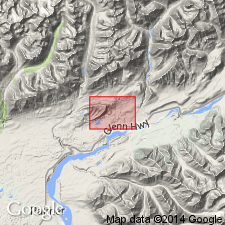
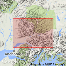
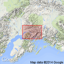
[Type locality not designated.] Typically exposed on Arkose Ridge, northwest of Wishbone Hill, [about 6 mi north of Palmer], southern AK. In belt extending along northern border of Matanuska Valley west of Chickaloon River.
Source: US geologic names lexicon (USGS Bull. 1200, p. 134-135); supplemental information from GNU records (USGS DDS-6; Menlo GNULEX).
- Usage in publication:
-
- Arkose Ridge Formation*
- Modifications:
-
- Age modified
- Biostratigraphic dating
- Geochronologic dating
- AAPG geologic province:
-
- Alaska Southern region
Summary:
Unit contains fossil plants of late Paleocene age (J.A. Wolfe, written commun., 1981). K-Ar ages (of three basalt flows, two rhyolite tuff units and ash flows in lower part of unit, also basalt dike near middle part of unit) range from 56.2 +/-1.7 Ma to 45.5 +/-1.8 Ma. These data suggest age is "within interval latest Paleocene to middle Eocene". p. 82. Age given as Paleocene or Eocene in figure.
Source: GNU records (USGS DDS-6; Menlo GNULEX).
- Usage in publication:
-
- Arkose Ridge Formation*
- Modifications:
-
- Age modified
- Biostratigraphic dating
- Geochronologic dating
- AAPG geologic province:
-
- Alaska Southern region
Summary:
Unit age is Paleocene and Eocene based on plant fossils and radiometric data.
Source: GNU records (USGS DDS-6; Menlo GNULEX).
For more information, please contact Nancy Stamm, Geologic Names Committee Secretary.
Asterisk (*) indicates published by U.S. Geological Survey authors.
"No current usage" (†) implies that a name has been abandoned or has fallen into disuse. Former usage and, if known, replacement name given in parentheses ( ).
Slash (/) indicates name conflicts with nomenclatural guidelines (CSN, 1933; ACSN, 1961, 1970; NACSN, 1983, 2005, 2021). May be explained within brackets ([ ]).