

- Usage in publication:
-
- Archusa marl member
- Modifications:
-
- Original reference
- Dominant lithology:
-
- Marl
- Limestone
- AAPG geologic province:
-
- Mid-Gulf Coast basin
Thomas, E.P., 1942, The Claiborne: Mississippi Geological Survey Bulletin, no. 48, 96 p.
Summary:
Pg. 49-52. Archusa marl member of Wautubbee formation. Defined as basal member of Wautubbee formation in eastern Mississippi. Interbedded marls and limestones. Thickness 45 to 60 feet; 48 feet at type locality; neither contact exposed. Underlies Potterchitto member (new), and where exposed contact is conformable and gradational. Overlies Kosciusko formation, and where exposed contact is disconformable and sharply defined. Age is Eocene.
Type locality: bluff beneath south end of bridge across Chickasawhay River on U.S. Highway 45, 2 mi south of Quitman, Clarke Co., eastern MS. Named from Archusa Springs, a health resort.
Source: US geologic names lexicon (USGS Bull. 1200, p. 127).
- Usage in publication:
-
- Archusa marl member*
- Modifications:
-
- Revised
- AAPG geologic province:
-
- Mid-Gulf Coast basin
Summary:
Archusa marl member of Cook Mountain formation. Assigned to Cook Mountain formation. Underlies Potterchitto sand member; overlies Sparta sand. [Age is Eocene.]
Source: US geologic names lexicon (USGS Bull. 1200, p. 127).
- Usage in publication:
-
- Archusa Marl Member
- Modifications:
-
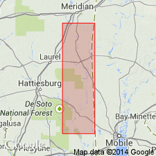
- Areal extent
- AAPG geologic province:
-
- Mid-Gulf Coast basin
Summary:
Archusa Marl Member of Cook Mountain Formation reaches a thickness of 60 ft in Clarke Co., MS. In the subsurface of southern MS, the Archusa probably comprises most or all of the interval commonly called Cook Mountain Limestone or the Camerina Limestone (from abundant CAMERINA BARKERI). The Archusa is noted for containing one of the few Eocene land mammal localities in the southeastern U.S. In western MS, the Archusa and overlying Potterchitto Member merge along the outcrop into the Shipps Creek Shale Member. Overlies the Dobys Bluff Tongue of the Kosciusko Formation.
Source: GNU records (USGS DDS-6; Reston GNULEX).
For more information, please contact Nancy Stamm, Geologic Names Committee Secretary.
Asterisk (*) indicates published by U.S. Geological Survey authors.
"No current usage" (†) implies that a name has been abandoned or has fallen into disuse. Former usage and, if known, replacement name given in parentheses ( ).
Slash (/) indicates name conflicts with nomenclatural guidelines (CSN, 1933; ACSN, 1961, 1970; NACSN, 1983, 2005, 2021). May be explained within brackets ([ ]).