The National Geologic Map Database is migrating to a new infrastructure. We apologize for any service disruptions during this process.
|
|---|


- Usage in publication:
-
- Archimedes limestone
- Modifications:
-
- Named
- Dominant lithology:
-
- Limestone
- AAPG geologic province:
-
- Arkoma basin
Summary:
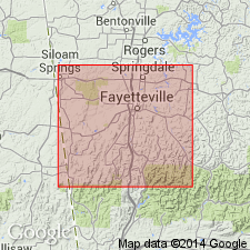
Archimedes limestone. Exposed in Washington County, Arkansas, in the Arkoma basin. Thins out to the north of "greatest development." Is well developed in the country south of Fayetteville, where it usually forms escarpments or bluffs. In general, consists of a light-gray, fossiliferous limestone from 25 to 40 feet thick. Has numerous pebbles and some pebbly shale. Overlies Marshall shale (new); underlies Washington shale and sandstone (new). Fossils: corals, crinoids, brachiopods. Age is Early Carboniferous. Report includes geologic map of Washington County, stratigraphic table, columnar sections.
Greatest development seen on the north face of the Boston Mountain Range, and in spurs and outliers of those mountains; here it enters conspicuously into the bench and bluff topography. Named from the bryozoan fossil ARCHIMEDES which is present in this formation.
Source: Modified from GNU records (USGS DDS-6; Denver GNULEX).

- Usage in publication:
-
- Archimedes limestone
- Modifications:
-
- Overview
Summary:
Paleontologic names applied in early Missouri reports to Chester, Meramec, and Osage groups of present [ca. 1938] terminology or to parts of these groups. "First Archimedes limestone" (also "Upper Archimedes limestone") was applied to the beds above Aux Vases sandstone and beneath a sandstone at Chester, Illinois, called by Swallow "Chester sandstone", which S. Weller stated is Palestine sandstone of modern nomenclature; "Second Archimedes limestone" was applied to Ste. Genevieve limestone; "Third Archimedes limestone" was applied to Warsaw limestone, also to Warsaw and Keokuk limestones, and to Keokuk limestone alone. "Lower Archimedes limestone" was also applied to the lower limestones. (See B.F. Shumard, 1873, Missouri Geol. Survey Rpt. 1855-1871, p. 292-293.) In northwest Arkansas and eastern Oklahoma "Archimedes limestone" was in early reports applied to Pitkin limestone.
Source: US geologic names lexicon (USGS Bull. 896, p. 68).
- Usage in publication:
-
- Cheshire quartzite*
- Modifications:
-
- Areal extent
- AAPG geologic province:
-
- New England province
Summary:
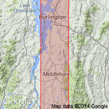
Pg. 525, 526-528. Cheshire quartzite. In stratigraphic succesion in west-central Vermont, Cheshire quartzite, about 1,000 feet thick, occurs above "Mendon series" and below Dunham dolomite. [Age is Early Cambrian.]
Source: US geologic names lexicon (USGS Bull. 1200, p. 753).
For more information, please contact Nancy Stamm, Geologic Names Committee Secretary.
Asterisk (*) indicates published by U.S. Geological Survey authors.
"No current usage" (†) implies that a name has been abandoned or has fallen into disuse. Former usage and, if known, replacement name given in parentheses ( ).
Slash (/) indicates name conflicts with nomenclatural guidelines (CSN, 1933; ACSN, 1961, 1970; NACSN, 1983, 2005, 2021). May be explained within brackets ([ ]).