The National Geologic Map Database is migrating to a new infrastructure. We apologize for any service disruptions during this process.
|
|---|


- Usage in publication:
-
- Anvil Points Member*
- Modifications:
-
- Overview
- Dominant lithology:
-
- Shale
- Sandstone
- Limestone
- AAPG geologic province:
-
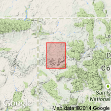
- Piceance basin
Summary:
First published detailed description of Anvil Points member--the middle member and one of five members--of Green River formation. Named for exposures at Anvil Points, sec 7, T6S, R94W. Type section measured in secs 12 and 13, T6S, R95W, Moffat Co, CO in the Piceance basin. Crops out as benches and cliffs in east part of area from Parachute Creek valley, Garfield Co, north beyond mouth of Piceance Creek, Rio Blanco Co. Is the lateral equivalent of the Douglas Creek and Garden Gulch members of the Green River, and to the shore facies of the Green River of the Gray Hills area, Moffat Co, CO. Cross sections; geologic map. Is 1,530 ft thick at type. Maximum thickness of 1,870 ft at upper Piceance Creek. Overlies Wasatch formation, an interfingering contact. Underlies and interfingers with Parachute Creek member of Green River. Lower contact at Anvil Points is red shale (Wasatch) with gray shale (Anvil Points). Upper contact is marlstone (Anvil Points) with marlstone and oil shale (Parachute Creek). At type, lower part consists mostly of interbedded gray shale and gray to brown sandstone and has five oolitic limestone beds; upper 300+/-ft is marlstone and sandstone. Regarded as early Eocene.
Source: GNU records (USGS DDS-6; Denver GNULEX).
- Usage in publication:
-
- Anvil Points Member
- Modifications:
-
- Revised
- AAPG geologic province:
-
- Piceance basin
- Green River basin
Summary:
A basal sandstone of the Green River Formation formerly assigned to the Douglas Creek Member of Green River reassigned to the Anvil Points Member as the newly named Piceance Creek Sandstone Tongue. Reassignment deemed necessary because Douglas Creek was derived from a western and southwestern source area whereas the Piceance Creek and the Anvil Points were derived from an eastern source. Eastern basin area extends from Grand Valley, Garfield Co, north into Rio Blanco Co, CO in the Piceance basin, and to the Gray Hills area of Moffat Co, CO in the Greater Green River basin. Areal extent map. Cross section. Eocene age.
Source: GNU records (USGS DDS-6; Denver GNULEX).
- Usage in publication:
-
- Anvil Points Member*
- Modifications:
-
- Revised
- AAPG geologic province:
-
- Piceance basin
Summary:
Boundaries of Anvil Points Member modified in that Long Point Bed named as a basal bed of the member. The upper contact placed at top of the newly named Kimball Mountain Tuff Bed of Anvil Points. The Long Point and Kimball Mountain are marker beds that are also present in other members. Long Point is the basal bed of the Garden Gulch and Douglas Creek Members of the Green River. Kimball Mountain is also part of the Parachute Creek, Douglas Creek, and Garden Gulch Members of the Green River. Anvil Points is mapped in the northeast part of basin in Moffat and Rio Blanco Cos, CO in the Piceance basin. Cross sections; measured sections.
Source: GNU records (USGS DDS-6; Denver GNULEX).
For more information, please contact Nancy Stamm, Geologic Names Committee Secretary.
Asterisk (*) indicates published by U.S. Geological Survey authors.
"No current usage" (†) implies that a name has been abandoned or has fallen into disuse. Former usage and, if known, replacement name given in parentheses ( ).
Slash (/) indicates name conflicts with nomenclatural guidelines (CSN, 1933; ACSN, 1961, 1970; NACSN, 1983, 2005, 2021). May be explained within brackets ([ ]).