The National Geologic Map Database is migrating to a new infrastructure. We apologize for any service disruptions during this process.
|
|---|


- Usage in publication:
-
- Antero formation
- Modifications:
-
- Original reference
- Dominant lithology:
-
- Limestone
- AAPG geologic province:
-
- South Park basin
Summary:
Pg. 77; J.T. Stark and others, 1949, GSA Mem. 33, p. 34 (table 7), 63-67, 170-171, pl. 1. Antero formation. Lacustrine sediments with some associated delta and flood plain deposits and beds of volcanic ash and agglomerate. Beds contain layers and reefs of algal limestones. Thickness about 2,010 feet. Underlies Wagontongue formation (new); overlies Balfour formation (new). Age is Oligocene.
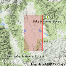
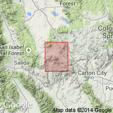
[Type area:] south and west of Hartsel in T. 12 to 15 S., R. 75 and 76 W.; occupies several long, narrow, and partly connected basins in the Precambrian north-northeast of Hartsel, in T. 10 and 11 S., R. 74 and 75 W., Park Co., central CO. [Antero Reservoir located a few mi southwest of Hartsel, in T. 12 S., R. 76 W., Antero Reservoir 7.5-min quadrangle, Park Co., central CO.]
Source: US geologic names lexicon (USGS Bull. 1200, p. 109).
- Usage in publication:
-
- Antero Formation
- Modifications:
-
- Revised
- AAPG geologic province:
-
- South Park basin
Summary:
Intertongues with and overlies the Agate Creek Formation, a newly named unit, in South Park basin. Divided into a lower tuff member and an upper member, both of Oligocene age. Geologic map.
Source: GNU records (USGS DDS-6; Denver GNULEX).
- Usage in publication:
-
- Antero Formation*
- Modifications:
-
- Revised
- AAPG geologic province:
-
- South Park basin
Summary:
Johnson's (1937) definition revised in that his lower part was renamed Tallahassee Creek Conglomerate by Epis and Chapin (1974) and his upper part was mapped as Trump Conglomerate by De Voto (1971), and as Wagontongue Formation by these authors. Name Antero applied only to middle part of Johnson's original unit that is a white, yellowish-gray and gray, platy siltstone, paper shale, and algal limestone. These lacustrine sediments are interlayered with numerous air-fall and ash-flow beds of Badger Creek Tuff. Where these lithologies intertongue, Antero and Badger Creek cannot be separately mapped. Revised Antero crops out over an area greater than 30 x 25 mi. Is a water-laid andesitic ash interbedded with air-fall and ash-flow tuff and lahar as much as 2,000 ft (600 m) thick. Overlies Tallahassee Creek Conglomerate and underlies Wagontongue. Is equivalent to Florissant Lake Beds. Has vertebrate fossils. Assigned an Oligocene age. Name Balfour Formation abandoned because it is equivalent in lithology, origin, and age to Antero. In South Park basin.
Source: GNU records (USGS DDS-6; Denver GNULEX).
- Usage in publication:
-
- Antero Formation*
- Modifications:
-
- Age modified
- AAPG geologic province:
-
- Denver basin
Summary:
Mapped with Gribbles Park, Thorn Ranch, and East Gulch Tuffs. Has a K-Ar age on biotite and sanidine of about 34 m.y. or Oligocene. Area where the four units are mapped is in Fremont Co, CO (Ts49 to 51N, Rs11 and 12E, T17S, R73W) in the Denver basin.
Source: GNU records (USGS DDS-6; Denver GNULEX).
For more information, please contact Nancy Stamm, Geologic Names Committee Secretary.
Asterisk (*) indicates published by U.S. Geological Survey authors.
"No current usage" (†) implies that a name has been abandoned or has fallen into disuse. Former usage and, if known, replacement name given in parentheses ( ).
Slash (/) indicates name conflicts with nomenclatural guidelines (CSN, 1933; ACSN, 1961, 1970; NACSN, 1983, 2005, 2021). May be explained within brackets ([ ]).