The National Geologic Map Database is migrating to a new infrastructure. We apologize for any service disruptions during this process.
|
|---|


- Usage in publication:
-
- Antelope shale
- Modifications:
-
- Original reference
- Dominant lithology:
-
- Shale
- AAPG geologic province:
-
- Sacramento basin
Summary:
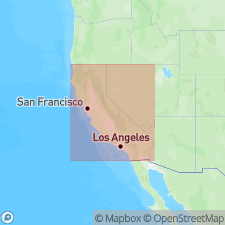
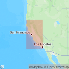
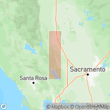
[Pg. 6, 7], correlation chart, structure sections A, B, and C. Antelope shale. Shown on correlation chart (of Rumsey Hills-Capay Valley-Wilbur Springs area) and on structure sections in Colusa County, California. Beds vertical to overturned. Thickness 4,200 to 5,200 feet. Underlies Venado sandstone; overlies Salt Creek conglomerate (new). Age is Late Cretaceous (Delevanian).
[Origin of name not stated. Type locality not designated.] Occurs in Rumsey Hills-Capay Valley-Wilbur Springs area on west side of Sacramento Valley, north-central CA.
Source: US geologic names lexicon (USGS Bull. 1200, p. 107-108); supplemental information from GNU records (USGS DDS-6; Menlo GNULEX).

- Usage in publication:
-
- Antelope shale
- Modifications:
-
- Biostratigraphic dating
- AAPG geologic province:
-
- Sacramento basin
Summary:
Pg. 40-47. Description of Upper Cretaceous pelagic Foraminifera from "Antelope shale" of Taliaferro (1954). Considered a provisional name. Kirby (1943, California Div. Mines Bull., no. 118) referred to these strata as Horsetown formation of Shasta group. J. Lawton (Stanford unpub. thesis) has proposed term Fiske Creek formation for "Antelope shale" which is junior homonym of Antelope formation (Miocene) of Kern County, described by Noble (1940, AAPG Bull., v. 27, no. 3). Age is early Late Cretaceous (Cenomanian), based on foraminifers. Comparisons made with fauna of type Calera limestone, Rockaway Beach, San Mateo County, California.
Source: US geologic names lexicon (USGS Bull. 107-108); supplemental information from GNU records (USGS DDS-6; Menlo GNULEX).
- Usage in publication:
-
- Antelope shale
- Modifications:
-
- Not used
- AAPG geologic province:
-
- Sacramento basin
Summary:
Pg. 2287. If it is desirable that Shasta series be restricted to Early Cretaceous, base of conglomerate below so-called Antelope shale of Taliaferro appears to good choice for its upper limit and is so considered in this report.
Source: US geologic names lexicon (USGS Bull. 1200, p. 107-108).
- Usage in publication:
-
- Antelope Shale
- Modifications:
-
- Biostratigraphic dating
- AAPG geologic province:
-
- Sacramento basin
Summary:
QUINQUECAPSULANIA SPINOSA Pessagno n.sp. has been found in five localities in "Antelope Shale"/"Fiske Creek Formation" in strata ranging in age from early to late Cenomanian (dating based on associated planktonic Foraminifera and Mollusca).
Source: GNU records (USGS DDS-6; Menlo GNULEX).
For more information, please contact Nancy Stamm, Geologic Names Committee Secretary.
Asterisk (*) indicates published by U.S. Geological Survey authors.
"No current usage" (†) implies that a name has been abandoned or has fallen into disuse. Former usage and, if known, replacement name given in parentheses ( ).
Slash (/) indicates name conflicts with nomenclatural guidelines (CSN, 1933; ACSN, 1961, 1970; NACSN, 1983, 2005, 2021). May be explained within brackets ([ ]).