The National Geologic Map Database is migrating to a new infrastructure. We apologize for any service disruptions during this process.
|
|---|


- Usage in publication:
-
- Andrew Lake Formation*
- Modifications:
-
- Named
- Dominant lithology:
-
- Sandstone
- Siltstone
- Shale
- AAPG geologic province:
-
- Aleutian Islands province
- Alaska Southwestern region
Summary:
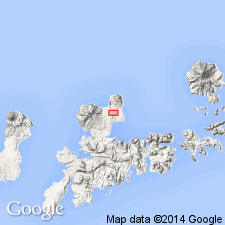
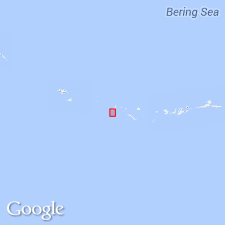
Type locality designated as exposures in low cliffs along east shore of Andrew Lake, north Adak Island, Aleutian Islands, southwest AK. Composed of sandstone, siltstone, and shale interlayered with mafic flows and sills. Attains 850 m thickness. Overlies Finger Bay Volcanics. Underlies unconformably upper Cenozoic eruptive rocks. Assigned middle or late Eocene age based on flora and fauna.
Source: GNU records (USGS DDS-6; Menlo GNULEX).
- Usage in publication:
-
- Andrew Lake Formation*
- Modifications:
-
- Age modified
- Revised
- AAPG geologic province:
-
- Aleutian Islands province
- Alaska Southwestern region
Summary:
Base of type Andrew Lake Formation lowered about 30 m, and upper contact lowered a lesser amount. Age revised from middle or late Eocene to late Eocene on basis of microfauna.
Source: GNU records (USGS DDS-6; Menlo GNULEX).
For more information, please contact Nancy Stamm, Geologic Names Committee Secretary.
Asterisk (*) indicates published by U.S. Geological Survey authors.
"No current usage" (†) implies that a name has been abandoned or has fallen into disuse. Former usage and, if known, replacement name given in parentheses ( ).
Slash (/) indicates name conflicts with nomenclatural guidelines (CSN, 1933; ACSN, 1961, 1970; NACSN, 1983, 2005, 2021). May be explained within brackets ([ ]).