

- Usage in publication:
-
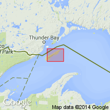
- Amygdaloid Island Flow*
- Modifications:
-
- Original reference
- Dominant lithology:
-
- Trap
- Basalt
- AAPG geologic province:
-
- Lake Superior region
Summary:
Pg. C18. Amygdaloid Island Flow of Portage Lake Volcanics. Composed of gray trap rock, andesite basalt. Thickness less than 15 m. Oldest of 12 named flows of Portage Lake Volcanics on Isle Royale; erupted before Hill Point Flow. Age is Precambrian Y.
Type locality: on promontory south of Crystal Cove at east end of Amygdaloid Island, north shore of eastern Isle Royale, Keweenaw Co., northwestern MI.
Source: US geologic names lexicon (USGS Bull. 1520, p. 9).
For more information, please contact Nancy Stamm, Geologic Names Committee Secretary.
Asterisk (*) indicates published by U.S. Geological Survey authors.
"No current usage" (†) implies that a name has been abandoned or has fallen into disuse. Former usage and, if known, replacement name given in parentheses ( ).
Slash (/) indicates name conflicts with nomenclatural guidelines (CSN, 1933; ACSN, 1961, 1970; NACSN, 1983, 2005, 2021). May be explained within brackets ([ ]).