The National Geologic Map Database is migrating to a new infrastructure. We apologize for any service disruptions during this process.
|
|---|


- Usage in publication:
-
- Amador group
- Modifications:
-
- Original reference
- Dominant lithology:
-
- Chert
- Volcanics
- AAPG geologic province:
-
- Sierra Nevada province
Summary:
Pg. 89-90. Amador group. Name substituted for preoccupied name Tuolumne (Taliaferro, 1933). Consists of clastic sediments and volcanics but chemical sediments such as red and green radiolarian chert, and dense nonfossiliferous limestones are common. Strongly folded and frequently faulted. Thickness less than 5,000 to more than 15,000 feet. Underlies the Mariposa [slates]. Age is Middle and Late Jurassic based on similar lithology and stratigraphic position of Dothan formation of southwestern Oregon.
Named from exposures along Cosumnes River, Amador Co., east-central CA.
Source: US geologic names lexicon (USGS Bull. 1200, p. 71-72); GNU records (USGS DDS-6; Menlo GNULEX).
- Usage in publication:
-
- Amador group*
- Modifications:
-
- Principal reference
- Revised
- AAPG geologic province:
-
- Sierra Nevada province
Summary:
Pg. 282-284, 303, 306 (fig. 2), 307 (fig. 3). Amador group. On Cosumnes and Calaveras Rivers, divisible into two formations (ascending): Cosumnes formation and Logtown Ridge agglomerates (both new). Thickness on Cosumnes River immediately west of Mother Lode Highway 7,100 feet; thicker to west and acutely folded. On Merced River, divisible into five formations: lower volcanics (thickness unknown, and base not exposed), pillow basalts (1,200 feet), Hunter Valley cherts (950 feet), Penon Blanco volcanics (about 9,000 feet), and Agua Fria (3,500 feet). Complete correlation of sections not established, but Logtown Ridge and Penon Blanco are correlated and pillow basalts and Hunter Valley cherts are equivalent to part of Cosumnes formation. Batholithic intrusions of granodiorite and diorite common, as are plugs, sills, and dikes of basic and ultrabasic rocks. Younger than Calaveras group (Clipper Gap formation) and older than Mariposa [slate]. Nearly everywhere Amador grades upward into Mariposa; north of Middle Fork of American River, Mariposa overlaps Amador. Occurs as long narrow belts, either flanking western Calaveras or rising as overturned anticlines from beneath Mariposa; overturning is commonly toward west, axial planes of folds dipping eastward at angles of 60 to 70 degrees. Exact age of Amador not known but believed to be from late Middle to early Late Jurassic, based on stratigraphic relations. Type sections designated. On various geologic folios, group of rocks here called Amador has been mapped as Calaveras, Mariposa, "diabase and porphyrite," amphibolite schist, and quartz amphibolite.
Type sections: north end is on Cosumnes River, El Dorado and Amador Cos. and south end is on Merced River, east-central CA.
Source: US geologic names lexicon (USGS Bull. 1200, p. 71-72); GNU records (USGS DDS-6; Menlo GNULEX).
- Usage in publication:
-
- Amador group*
- Modifications:
-
- Revised
- AAPG geologic province:
-
- Sierra Nevada province
Summary:
Pg. 5-6. Amador group. Includes sequence of Middle and Upper Jurassic sandstones, conglomerates, bedded tuffs, chert, slates, limestone, and thick layers of augite andesite and dacitic volcanic rocks. Parts of the Calaveras formation and amphibolite schists, diabase, and porphyrite as mapped by Turner, 1897 (USGS Geol. Atlas U.S., Sonora folio, no. 41) belong in the Amador group. Underlies Mariposa slate. Unconformably overlies Calaveras formation. The Calaveras, Amador, and Mariposa are all intruded by masses of peridotite, gabbro, diorite, and granodiorite; structure exceedingly complex.
Source: Publication; GNU records (USGS DDS-6; Menlo GNULEX).
- Usage in publication:
-
- Amador group*
- Modifications:
-
- Revised
- AAPG geologic province:
-
- Sierra Nevada province
Summary:
Pg. 51-53, pl. 7. Series of schists and greenstone in Newton copper mine area (near Jackson, Amador County, California) tentatively correlated with the Jurassic Amador group described by Taliaferro, 1942 (GSA Bull., v. 53, no. 1), is subdivided into 4 formations (descending) Mountain Spring volcanics, Dufrene slate, Newton Mine volcanics, and Sunnybrook volcanics (all new). Approximate thickness of section 2,057 feet. Section described exposed in western part of area from Mariposa slate eastward along Mountain Spring Creek to Newton mine [section does not include the Sunnybrook volcanics]. In general rocks dip steeply eastward; in some places are vertical; graded bedding suggests that rocks lie on western, overturned limb of major anticline and become progressively older eastward. Age is Jurassic. Mapped in Newton mine area (scale 1:400).
Source: US geologic names lexicon (USGS Bull. 1200, p. 71-72); GNU records (USGS DDS-6; Menlo GNULEX).
- Usage in publication:
-
- Amador group*
- Modifications:
-
- Areal extent
- AAPG geologic province:
-
- Sierra Nevada province
Summary:
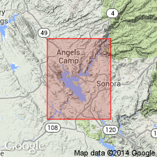
Pg. 10-11, pls. 1, 2. Amador group. Described in Angels Camp and Sonora 7.5-min quadrangles, Calaveras and Tuolumne Counties, east-central California, where it includes (ascending) Cosumnes and Logtown Ridge formations. Thickness 8,000 +/-50 feet. Age is Middle or Late Jurassic.
Source: US geologic names lexicon (USGS Bull. 1200, p. 71-72); GNU records (USGS DDS-6; Menlo GNULEX).
- Usage in publication:
-
- Amador Group*
- Modifications:
-
- Age modified
- AAPG geologic province:
-
- Sierra Nevada province
Summary:
Age of Amador group which includes (ascending) the Cosumnes and Logtown Ridge formations revised from Middle or Late Jurassic to: Middle(?) and Late Jurassic, to agree with age revision of Cosumnes formation.
Source: GNU records (USGS DDS-6; Menlo GNULEX).
- Usage in publication:
-
- Amador group*
- Modifications:
-
- Revised
- Areal extent
- Age modified
- AAPG geologic province:
-
- Sierra Nevada province
Summary:
Pg. 17, pls. 1-11 (see also L.D. Clark and others, 1963, San Andreas quadrangle, USGS Geol. Quad. Map GQ-222). Amador group of Taliaferro (1943, California Div. Mines Bull., no. 125) is restricted to its northern area, north of Mokelumne River, around the Cosumnes River, in El Dorado and Amador Counties; includes only Logtown Ridge and Cosumnes formations. Type section (pl. 10) extends west from Huse Bridge on Highway 49 where Logtown Ridge formation is in depositional contact with overlying unnamed epiclastic sequence previously included with Mariposa formation. Upper contact of the Logtown is at base of lowermost epiclastic bed of the overlying sequence. Lower contact of the Amador group [Cosumnes formation] is about 2.1 miles southwest of Huse Bridge. Contact between Logtown Ridge and Cosumnes formations is placed at top of slate layer of Cosumnes exposed on north side of river about 7,400 feet southwest of Huse Bridge, is parallel to graded-bedding in both formations. The Mountain Spring volcanics and Newton Mine volcanics (tentatively correlated with the Amador group by Heyl and Eric, 1948, California Div. Mines Bull., no. 144) are replaced by part of Copper Hill volcanics (new) as is part located near Copperopolis (Heyl, 1948, California Div. Mines Bull., no. 144, p. 99). Age is Middle and Late Jurassic.
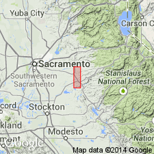
Type section (=northern type section of Taliaferro, 1943, California Div. Mines Bull., no. 125): on Consumnes River, extending west from Huse Bridge on Highway 49 to about 2.1 mi southwest of Huse Bridge, in vicinity of Lat. 38 deg. 32 min. 30 sec. N., Long. 120 deg. 52 min. 30 sec. W., southwestern El Dorado and northwestern Amador Cos., CA.
[Author does not capitalize rank terms; however, units are considered formal.]
Source: Publication; GNU records (USGS DDS-6; Menlo GNULEX).
- Usage in publication:
-
- Amador Group†
- Modifications:
-
- Abandoned
- AAPG geologic province:
-
- Sierra Nevada province
Summary:
Amador Group defined by Taliaferro to include the Cosumnes and overlying Logtown Ridge Formations along Cosumnes River abandoned because [group] refers to two unrelated structurally juxtaposed stratified rock units. Formation names remain in good standing.
Source: GNU records (USGS DDS-6; Menlo GNULEX).
For more information, please contact Nancy Stamm, Geologic Names Committee Secretary.
Asterisk (*) indicates published by U.S. Geological Survey authors.
"No current usage" (†) implies that a name has been abandoned or has fallen into disuse. Former usage and, if known, replacement name given in parentheses ( ).
Slash (/) indicates name conflicts with nomenclatural guidelines (CSN, 1933; ACSN, 1961, 1970; NACSN, 1983, 2005, 2021). May be explained within brackets ([ ]).