

- Usage in publication:
-
- Alsea Formation*
- Modifications:
-
- Age modified
- Biostratigraphic dating
- AAPG geologic province:
-
- Oregon-Washington Coast Ranges province
Summary:
Kleinpell and Weaver (1963) placed lower part of Refugian Stage in uppermost part of Pacific coast Eocene sequence whereas upper part of Refugian and all of Zemorrian Stage are Oligocene. On this basis Alsea Formation is entirely in Oligocene with possible exception that lowest part may be in uppermost part of Eocene(?).
Source: GNU records (USGS DDS-6; Menlo GNULEX).
- Usage in publication:
-
- Alsea Formation*
- Modifications:
-
- Original reference
- Biostratigraphic dating
- Dominant lithology:
-
- Siltstone
- Sandstone
- AAPG geologic province:
-
- Western Columbia basin
Summary:
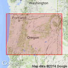
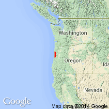
Alsea Formation. Rocks formerly included in upper part of †Toledo Formation (abandoned). Crops out in a 65-km-long arcuate belt along central Oregon coast, from Alsea Bay area north to Siletz Bay. Consists of gray marine tuffaceous siltstone and very fine-grained sandstone with interbedded mudstone, glauconitic sandstone, fine-grained tuff, and reworked lapilli tuff. Thickness is from 50 to 1,100 m. Conformably overlies Nestucca Formation (late Eocene) and unnamed basaltic sandstone of latest Eocene age. Conformably underlies and interbedded with Yaquina Formation (late Oligocene and early Miocene). Abundant molluscan and foraminiferal faunas indicate an early (upper Refugian-"Lincoln" Stage) to late (Zemorrian-lower "Blakeley" Stage) Oligocene age. Report includes geologic maps, chemical analyses, faunal lists and plates. Alsea Formation adopted by the USGS.
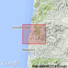
Type section: lower part on north side and upper part on southern side of Alsea Bay, in secs. 17 through 20, T. 13 S., R. 12 W., Lincoln Co., northwestern OR. Named from exposures along shores of Alsea Bay.
Reference section: at outcrops and roadcuts along northern side of Yaquina River, in NE/4 sec. 35 to SW/4 sec. 26, T. 11 S., R. 11 W., Lincoln Co., northwestern OR.
[Misprint: US geologic names lexicon (USGS Bull. 1520, p. 8) states type section is on north side of Alsea Bay and formation is recognzied in west-central Oregon. Type section is on north -and- south side of Alsea Bay; formation is recognized in northwestern Oregon (Snavely and others, 1975, p. F1, F4 (fig. 2); GNU records (USGS DDS-6; Menlo GNULEX); Changes in stratigraphic nomenclature (USGS Bull. 1422-A, p. A2).]
Source: Publication; GNU records (USGS DDS-6; Menlo GNULEX); Changes in stratigraphic nomenclature, 1975 (USGS Bull. 1422-A, p. A2-A3); US geologic names lexicon (USGS Bull. 1520, p. 8).
- Usage in publication:
-
- Alsea Formation*
- Modifications:
-
- Biostratigraphic dating
- AAPG geologic province:
-
- Oregon-Washington Coast Ranges province
Summary:
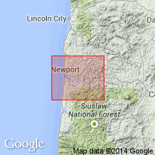
Mapped in Yaquina Bay area in Yaquina and Toledo 15' quads, Lincoln Co., OR. Is massive to thick-bedded fossiliferous concretionary tuffaceous marine siltstone and very fine grained sandstone; altered glass shards make up large proportion of siltstone. Underlies Yaquina Formation; overlies Nestucca Formation. Age is Oligocene based on fossils [molluscan and foraminiferal fauna].
Source: GNU records (USGS DDS-6; Menlo GNULEX).
- Usage in publication:
-
- Alsea Formation*
- Modifications:
-
- Biostratigraphic dating
- AAPG geologic province:
-
- Oregon-Washington Coast Ranges province
Summary:
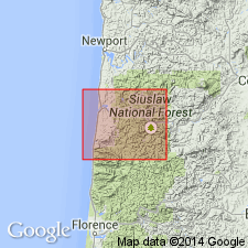
Mapped in Alsea Bay area in Waldport 15' quad, Lincoln Co., OR. Is massive to thick-bedded fossiliferous tuffaceous marine siltstone and very fine grained sandstone, locally concretionary and with glauconitic and micaceous sandstone and tuff interbeds. Underlies Yaquina Formation (late Oligocene age) and Pleistocene coastal terrace deposits. Overlies unnamed basaltic sandstone (late Eocene age) and Yachats Basalt (late Eocene age). Assigned early to late Oligocene age based on foraminiferal assemblages within siltstone and marine mollusks.
Source: GNU records (USGS DDS-6; Menlo GNULEX).
- Usage in publication:
-
- Alsea Formation*
- Modifications:
-
- Biostratigraphic dating
- AAPG geologic province:
-
- Oregon-Washington Coast Ranges province
Summary:
Mapped in Cape Foulweather and Euchre Mountain 15' quads, Lincoln Co., OR. Is massive to thick-bedded fossiliferous tuffaceous marine siltstone and very fine grained sandstone locally concretionary. Lens of thick-bedded arkosic and glauconitic marine sandstone north of the Siletz River shown separately. Underlies Yaquina Formation (late Oligocene and early Miocene age) and Holocene alluvial deposits. Overlies Nestucca Formation (late Eocene age). Assigned Oligocene age based on foraminiferal assemblages of Zemorrian and upper Refugian Stage of Kleinpell (1938).
Source: GNU records (USGS DDS-6; Menlo GNULEX).
- Usage in publication:
-
- Alsea Formation*
- Modifications:
-
- Areal extent
- AAPG geologic province:
-
- Oregon-Washington Coast Ranges province
Summary:
Shown in cross section on inner continental shelf at approximately 44 deg 51'N, 124 deg 05' to 124 deg 30'W based on seismic reflection data, Standard-Union Nautilus No.1 (P-0103) well data, and Snavely and others (1976) onshore map of Cape Foulweather and Euchre Mountain 15' quads. Underlies Nye Mudstone (early Miocene age); overlies Nestucca Formation and Yachats Basalt. Assigned Oligocene age.
Source: GNU records (USGS DDS-6; Menlo GNULEX).
- Usage in publication:
-
- Alsea Formation*
- Modifications:
-
- Age modified
- Biostratigraphic dating
- AAPG geologic province:
-
- Oregon-Washington Coast Ranges province
Summary:
Strata correlative with Alsea Formation shown in cross section on inner continental shelf W at 44 deg 12'N. Side wall cores from several wells consist of light-gray and light olive-gray massive tuffaceous silty claystone and siltstone with minor amounts of glauconite, mica and carbonaceous material. Underlies Nye Mudstone-Astoria Fm (undivided); overlies Nestucca Fm and Yachats Basalt. Foraminiferal fauna typical of onshore Alsea Formation occur in this offshore argillaceous unit which is assigned late Eocene Refugian Stage and Oligocene Zemorrian Stage. Correlation chart shows Alsea Formation to be late Eocene and Oligocene age.
Source: GNU records (USGS DDS-6; Menlo GNULEX).
For more information, please contact Nancy Stamm, Geologic Names Committee Secretary.
Asterisk (*) indicates published by U.S. Geological Survey authors.
"No current usage" (†) implies that a name has been abandoned or has fallen into disuse. Former usage and, if known, replacement name given in parentheses ( ).
Slash (/) indicates name conflicts with nomenclatural guidelines (CSN, 1933; ACSN, 1961, 1970; NACSN, 1983, 2005, 2021). May be explained within brackets ([ ]).