The National Geologic Map Database is migrating to a new infrastructure. We apologize for any service disruptions during this process.
|
|---|


- Usage in publication:
-
- Alpreston quartzite*
- Modifications:
-
- Original reference
- Dominant lithology:
-
- Quartzite
- AAPG geologic province:
-
- Montana folded belt
Summary:
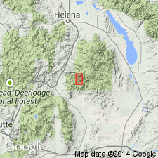
Pg. 434, 435. Alpreston quartzite. Nearly white, altered sandstone (quartzite) of great hardness. Thickness 125 feet. Occurs above Algonkian(?) age Turnley quartzitic hornstone, and below Starmount limestones (which correspond in character and position to Meagher limestone of Little Belt Mountains). Alpreston and Starmount are separated by a granite-porphyry intrusion. Alpreston quartzite probably = Flathead quartzite. Is oldest Cambrian unit in Elkhorn district. Report includes geologic map, cross sections, stratigraphic section.
Type locality not designated. Forms crest of hill west of Elkhorn, Jefferson Co., west-central MT. [This hill is also to west of Alpreston Gulch. Origin of name not stated, but probably named from Alpreston Gulch near town of Elkorn.]
Source: US geologic names lexicon (USGS Bull. 896, p. 37); supplemental information from GNU records (USGS DDS-6; Denver GNULEX).
For more information, please contact Nancy Stamm, Geologic Names Committee Secretary.
Asterisk (*) indicates published by U.S. Geological Survey authors.
"No current usage" (†) implies that a name has been abandoned or has fallen into disuse. Former usage and, if known, replacement name given in parentheses ( ).
Slash (/) indicates name conflicts with nomenclatural guidelines (CSN, 1933; ACSN, 1961, 1970; NACSN, 1983, 2005, 2021). May be explained within brackets ([ ]).