The National Geologic Map Database is migrating to a new infrastructure. We apologize for any service disruptions during this process.
|
|---|


- Usage in publication:
-
- Alfred Complex
- Modifications:
-
- Original reference
- Dominant lithology:
-
- Gabbro
- Quartz diorite
- AAPG geologic province:
-
- New England province
Summary:
Pg. 51-53, pls. 1, 2; 1961, Dissert. Abs., v. 22, no. 5, p. 1581. Alfred Complex. Basic igneous complex. Consists of noritic gabbro, marginally altered to quartz diorite, a thin layer or layers of anorthositic gabbro associated with the noritic gabbro; a ring-shaped mass of monzodiorite; and an elliptical mass of porphyritic granodiorite in center of monzodiorite. Other complexes in area are: Tatnic, Cape Neddick, and Agamenticus. Younger than Agamenticus Complex. Age given as Permian(?) and later. [Age is considered Triassic(?) according to US geologic names lexicon, USGS Bull. 1350, p. 13.]
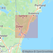
Underlies a series of arcuate hills on northwestern side of Lyman pluton near Alfred village, York Co., southwestern ME.
Source: US geologic names lexicon (USGS Bull. 1350, p. 13); supplemental information from GNU records (USGS DDS-6; Reston GNULEX).
- Usage in publication:
-
- Alfred Complex
- Modifications:
-
- Revised
- AAPG geologic province:
-
- New England province
Summary:
Alfred Complex assigned to White Mountain Plutonic Volcanic Series. Age given as Jurassic.
Source: GNU records (USGS DDS-6; Reston GNULEX).
For more information, please contact Nancy Stamm, Geologic Names Committee Secretary.
Asterisk (*) indicates published by U.S. Geological Survey authors.
"No current usage" (†) implies that a name has been abandoned or has fallen into disuse. Former usage and, if known, replacement name given in parentheses ( ).
Slash (/) indicates name conflicts with nomenclatural guidelines (CSN, 1933; ACSN, 1961, 1970; NACSN, 1983, 2005, 2021). May be explained within brackets ([ ]).