The National Geologic Map Database is migrating to a new infrastructure. We apologize for any service disruptions during this process.
|
|---|


- Usage in publication:
-
- Alferitz formation
- Modifications:
-
- Original reference
- Dominant lithology:
-
- Siltstone
- AAPG geologic province:
-
- San Joaquin basin
Summary:
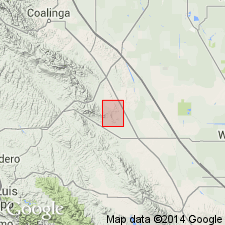
Pg. 496-500. Alferitz formation. Whitish to yellowish siltstone containing orange concretionary layers and occasional thin poorly sorted sands. Maximum thickness 700 feet. Unconformably underlies McLure shale; overlies Escudo sandstone (new). Age is middle Miocene (Luisian).
[Type lcoality not stated. Occurs in Devils Den oil field district, northwestern Kern Co., adjacent to Kings Co. line, about 40 mi east of Paso Robles and about 60 mi northwest of Bakersfield, central CA.]
Source: US geologic names lexicon (USGS Bull. 1200, p. 49).
For more information, please contact Nancy Stamm, Geologic Names Committee Secretary.
Asterisk (*) indicates published by U.S. Geological Survey authors.
"No current usage" (†) implies that a name has been abandoned or has fallen into disuse. Former usage and, if known, replacement name given in parentheses ( ).
Slash (/) indicates name conflicts with nomenclatural guidelines (CSN, 1933; ACSN, 1961, 1970; NACSN, 1983, 2005, 2021). May be explained within brackets ([ ]).