The National Geologic Map Database is migrating to a new infrastructure. We apologize for any service disruptions during this process.
|
|---|


- Usage in publication:
-
- Aldrich Mountains Group*
- Modifications:
-
- Original reference
- Dominant lithology:
-
- Graywacke
- Shale
- Tuff
- AAPG geologic province:
-
- Blue Mountains province
Summary:
Aldrich Mountains Group. Formal proposal of name. Forms eastern two-thirds of mountains. Includes (ascending): Fields Creek Formation, Laycock Graywacke, Murderers Creek Graywacke, and Keller Creek Shale (all new). Formations have composite thickness up to 35,000 feet. Composed mostly of graywacke and shale, water-laid volcanic tuff, siliceous mudstone and chert, and basaltic lava. Intruded by rocks of Canyon Mountain Complex. Unconformably underlies sedimentary and volcanic rocks of Early Jurassic age. Age is Late Triassic(?) and Early Jurassic. Aldrich Mountains Group adopted by the USGS.
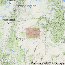
Named for Aldrich Mountains, northeast OR. Because of lenticular nature of deposits no type section designated for group.
Source: US geologic names lexicon (USGS Bull. 1350, p. 13); Changes in stratigraphic nomenclature, 1965 (USGS Bull. 1244-A, p. A2); GNU records (USGS DDS-6; Menlo GNULEX).
- Usage in publication:
-
- Aldrich Mountains Group*
- Modifications:
-
- Overview
- AAPG geologic province:
-
- Blue Mountains province
Summary:
Pg. A25-A29. Aldrich Mountains Group (Brown and Thayer, 1966, USGS Misc. Inv. Ser. Map I-447). Comprises Upper Triassic and (or) Lower Jurassic rocks that form eastern two-thirds of the Aldrich Mountains, Grant County, northeastern Oregon. Includes (ascending): Fields Creek Formation, Laycock Graywacke, Murderers Creek Graywacke, and Keller Creek Shale. Group has a maximum thickness of about 35,000 feet; consists mostly of graywacke and shale, waterlaid volcanic tuff, siliceous mudstone and chert, and basaltic pillow lava. A thick tongue of tuff in the Fields Creek Formation is named Cinnabar Tuff Tongue; and a tongue in the Laycock Graywacke is named Ingle Tuff Tongue.
Source: Publication.

- Usage in publication:
-
- Aldrich Mountains Group*
- Modifications:
-
- Revised
- AAPG geologic province:
-
- Blue Mountains province
Summary:
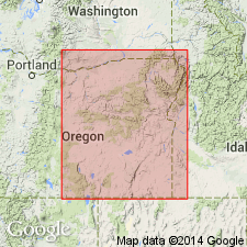
Formations of Aldrich Mountains Group mapped in Mount Vernon 15-min quadrangle, Grant County, Oregon, include (ascending): Field Creek Formation, Laycock Graywacke, Murderers Creek Graywacke, and Keller Creek Shale. Composite thickness is at least 27,500 feet. Field Creek Formation includes in its upper half newly named andesitic Cinnabar Tuff Tongue. Laycock Graywacke includes newly named Ingle Tuff Tongue. Group overlies Canyon Mountain Complex with angular unconformity. Underlies Clarno Formation and Rattlesnake Formation with angular unconformity. Intruded by dioritic porphyry of Early Cretaceous age. Age is Late Triassic(?) and Early Jurassic.
Source: Modified from GNU records (USGS DDS-6; Menlo GNULEX).
- Usage in publication:
-
- Aldrich Mountains Group*
- Modifications:
-
- Mapped
- AAPG geologic province:
-
- Blue Mountains province
Summary:
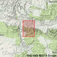
Fields Creek Formation of Aldrich Mountains Group is mapped in Aldrich Mountain 15' quad, Grant Co, OR. Intruded by diorite porphyry and related rocks of Early Cretaceous age. Overlies with angular unconformity Vester Formation; also overlies unnamed Paleozoic rocks. Underlies with angular unconformity Rattlesnake Formation; also unconformably underlies Pleistocene alluvium. Fields Creek Formation is assigned Late Triassic(?) age.
Source: GNU records (USGS DDS-6; Menlo GNULEX).
- Usage in publication:
-
- Aldrich Mountain[s] Group
- Modifications:
-
- Overview
- AAPG geologic province:
-
- Blue Mountains province
Summary:
Pg. 3. Aldrich Mountain[s] Group. Defined by Brown and Thayer (1966, USGS Misc. Inv. Ser. Map I-447). Consists of conformable sequence of Late Triassic and Early Jurassic sedimentary rocks exposed on south limb of Aldrich Mountain[s] anticline. Includes (in ascending order) Fields Creek Formation, Laycock Graywacke, Murderers Creek Graywacke, and Kellers Creek Shale. Relationship of the Aldrich Mountain[s] Group to the Mesozoic section of Dickinson and Vigrass (1965) to the south in Suplee-Izee district is unclear. Aldrich Mountain[s] Group predates Mowich Group; roughly correlates with Graylock Formation. Probably occurs stratigraphically above Brisbois and Begg Formations.
See also Dickinson, W.R., and Vigrass, L.W., 1965, "Geology of the Suplee-Izee area, Cook, Grant, and Harney Counties, Oregon," Oregon Dept. Geol. and Min. Ind. Bull., no. 58, 109 p., geol. map (scale 1:42,000).
Source: Publication.
- Usage in publication:
-
- Aldrich Mountains Group*
- Modifications:
-
- Age modified
- AAPG geologic province:
-
- Blue Mountains province
Summary:
Rocks of Aldrich Mountains Group form series of folded sedimentary wedges that overlap progressively from north and west and thin toward center of Aldrich-Izee basin. Fields Creek Formation is no older than late Late Triassic (N.J. Silberling, written commun., 1963) because transported blocks of reef limestone containing HALORELLA occur in shale near Horseshoe Butte in basal part of formation. Fossils of Sinemurian Age [Early Jurassic] (R.W. Imlay, written commun., 1961) occur in Murderers Creek Graywacke in place west of HWY 395 in northeast corner of Logdell quad. Age for Aldrich Mountains Group is Late Triassic and Early Jurassic.
Source: GNU records (USGS DDS-6; Menlo GNULEX).
For more information, please contact Nancy Stamm, Geologic Names Committee Secretary.
Asterisk (*) indicates published by U.S. Geological Survey authors.
"No current usage" (†) implies that a name has been abandoned or has fallen into disuse. Former usage and, if known, replacement name given in parentheses ( ).
Slash (/) indicates name conflicts with nomenclatural guidelines (CSN, 1933; ACSN, 1961, 1970; NACSN, 1983, 2005, 2021). May be explained within brackets ([ ]).