

- Usage in publication:
-
- Albuquerque Marl
- Modifications:
-
- Original reference
- Dominant lithology:
-
- Marl
- AAPG geologic province:
-
- Estancia basin
- San Juan basin
Summary:
Albuquerque marl. [Applied to upper part of so-called Albuquerque series (also called Rio Grande series).] Yellowish-white marl, 6 feet thick, "which occurs on both sides of Rio Grande, and which may henceforth be known as the Albuquerque marl." Age is late Tertiary.
[Named from occurrence on both sides of Rio Grande, in Albuquerque region, central northern NM.]
Source: US geologic names lexicons (USGS Bull. 896, p. 28, Rio Grande entry p. 1816-1817; USGS Bull. 1200, p. 43-44).
- Usage in publication:
-
- Albuquerque marl
- Modifications:
-
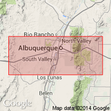
- Areal extent
- AAPG geologic province:
-
- Estancia basin
Summary:
Pg. 86. Albuquerque marl. In Rio Grande embayment the Pliocene marls will be called Albuquerque marls. In Jemez region they are called Jemez marls. They are a continuation of Santa Fe marls of Cope. At Albuquerque they are 350 feet thick; in Jemez region 100 to 250 feet. They are older than Piacita marl (Pleistocene), and rest on a series of alternating softer and harder calcareous sandstones and conglomerates, of white to deep green colors.
[Recognized in Albuquerque region, central northern NM.]
Source: US geologic names lexicon (USGS Bull. 896, p. 28).
- Usage in publication:
-
- Albuquerque marl
- Modifications:
-
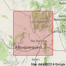
- Areal extent
- AAPG geologic province:
-
- Estancia basin
- San Juan basin
Summary:
Pg. 806. Albuquerque marl. Mentioned in discussion of Santa Fe formation. Herrick recognized dissimilarities between valley fill at Albuquerque and Santa Fe marls of Hayden (1869) and Cope (1874, US Geol. Geog. Survey W. 100th Mer., Wheeler Rpt., p. 115-130), but his attention was largely directed to caliche on the upland surface, which he regarded as lake deposit. His term Albuquerque marl applies strictly to the caliche. [Age is late Tertiary.]
Source: US geologic names lexicon (USGS Bull. 1200, p. 43-44).
For more information, please contact Nancy Stamm, Geologic Names Committee Secretary.
Asterisk (*) indicates published by U.S. Geological Survey authors.
"No current usage" (†) implies that a name has been abandoned or has fallen into disuse. Former usage and, if known, replacement name given in parentheses ( ).
Slash (/) indicates name conflicts with nomenclatural guidelines (CSN, 1933; ACSN, 1961, 1970; NACSN, 1983, 2005, 2021). May be explained within brackets ([ ]).